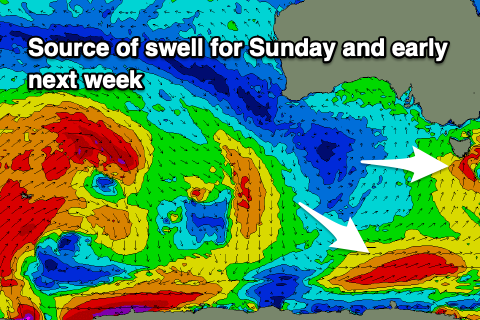
Increased swell activity into the weekend and next week
Southern Tasmanian Surf Forecast by Craig Brokensha (issued Friday June 28th)
Best Days: Tomorrow, Monday morning, Tuesday, Wednesday
Features of the Forecast (tl;dr)
- Easing SW groundswell tomorrow with fresh N tending N/NW then strong W/NW winds
- Poor S swell Sun with strong SW tending S/SW winds
- Easing S swell Mon with some better S/SW swell arriving through the day, holding Tue, easing Wed
- W/NW-NW winds Mon, tending W/SW later, NW tending variable Tue/Wed
Recap
Yesterday was tiny with 1-1.5ft of swell leftover from Wednesday afternoon, while today there’s been a kick in swell this afternoon, that being a distant groundswell that’s come in better than expected with 2ft sets (though wind affected).

New swell coming in stronger than expected this afternoon
This weekend and next week (Jun 29 - Jul 5)
This afternoon’s inconsistent SW groundswell should still be in the water tomorrow with clean, easing sets from 2ft under a gusty N tending N/NW and then strong W/NW breeze.
This shift in wind is thanks to a developing mid-latitude low moving in from the west on the weekend, with it due to be quite quick moving compared to the forecasts earlier in the week.

We’re expected to see it move across us on Sunday bringing a strong SW tending S/SW change and kick in low quality swell to 3-4ft, easing back Monday from 2-3ft with W/NW-NW winds, tending W/SW later in the day.
Behind the low healthy polar frontal systems will be drawn up from the south-west, with some good, reinforcing S/SW swell energy due into Monday afternoon and Tuesday, coming in at 3ft or so.
NW tending variable winds are due Tuesday, similar Wednesday as the S/SW swell energy eases.
We then look at a small run of surf through Thursday ahead of some good W/SW groundswell into the end of the week and weekend. The source will be an east-southeast tracking frontal system from the Indian Ocean, generating a great fetch of gale to severe-gale W/NW winds in our south-western swell window.
Size wise it looks to be in the 3-4ft range but we’ll check this Monday. Have a great weekend!

