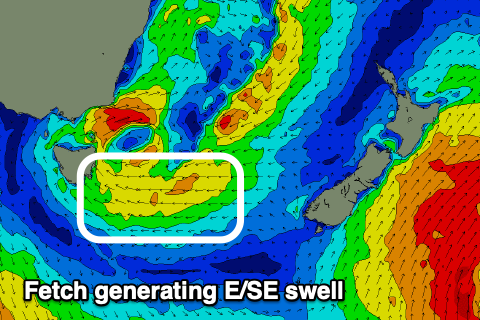
Fun weekend with a funky E/SE swell next week
Southern Tasmanian Surf Forecast by Craig Brokensha (issued Friday May 31st)
Best Days: Tomorrow, Saturday, selected spots Tuesday, Wednesday morning
Features of the Forecast (tl;dr)
- Small-mod sized mid-period SW swell building tomorrow, easing Sun
- NW tending variable winds tomorrow, N/NW tending variable Sun
- Small groundswell Mon with strengthening S/SE winds
- Small-mod sized E/SE swell building Mon, peaking Tue with strong S/SW-SW winds
- Easing swell Wed with W/NW morning winds
Recap
Fading surf the last two days, tiny into this morning.
This weekend and next week (Jun 1 - 7)
There’s no real change to the weekend’s outlook with a strong but weakening low due to generate some fun mid-period SW swell tomorrow, building through the afternoon, reaching 2ft+ and then easing from a similar size Sunday morning.
Winds look great tomorrow and NW tending variable, with similar N/NW tending variable winds Sunday.
Into Monday a tricky pulse of W/SW groundswell is due, likely to 1-2ft, generated by a short-lived but strong frontal system dipping south-east through our swell window tomorrow.

Winds unfortunately look average and deteriorating as a low moving down the East Coast interferes with us, bringing strengthening S/SE winds.
The low will sit just east of us Tuesday, maintaining strong S/SW-SW winds on Tuesday along with some new mid-period E/SE energy.
This will be generated on the southern flank of the low and should reach 2ft+ on Tuesday across Clifton, easing slowly Wednesday. Locations further down the Arm will be bigger.
Winds look to tip back to the W/NW on Wednesday morning with 2ft of easing E/SE swell, with nothing too significant to follow. More on this Friday, have a great weekend!

