Fun period of surf ahead
Southern Tasmanian Forecast by Craig Brokensha (issued Friday May 24th)
Best Days: This afternoon, tomorrow, Sunday, Monday morning, Tuesday, Wednesday
Features of the Forecast (tl;dr)
- Easing swell tomorrow with N/NW tending variable winds
- New moderate sized S/SW swell Sun AM, easing, smaller Mon
- N/NW tending NE winds Sun
- NW-W/NW winds Mon, shifting W/SW into the PM
- Small, inconsistent S/SE swell later Mon, peaking Tue, persisting the rest of the week
- N/NW-NW winds Tue
- N winds Wed with an inconsistent W/SW groundswell
Recap
The surf bottomed out into yesterday morning, while today we’ve got building levels of mid-period SW swell but with less than ideal winds.

New swell building this afternoon
This weekend and next week (May 25 - 31)
This afternoon’s pulse of SW swell is due to ease back through tomorrow from 2-3ft across Clifton with a nice offshore N/NW tending variable wind.
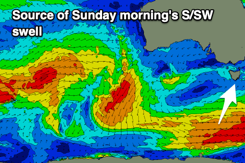
Our reinforcing pulse of S/SW swell energy from a late, strengthening polar frontal system south of us today should show late tomorrow, but Sunday morning should offer more reliable 2-3ft sets under a N/NW tending NE breeze, with the swell easing back from 2ft Monday.
Also in the mix will be an inconsistent W/SW groundswell but sets don’t look to top 2ft, with it generated in our far swell window, south of the Indian Ocean.

W/NW-NW winds will create clean conditions on Monday morning, shifting W/SW into the afternoon as a front clips us.
The rest of the week is flukier, with inconsistent levels of S/SE groundswell due from later Monday, peaking Tuesday but persisting most of next week, generated by multiple fetches of strong to gale-force S’ly winds firing up south of New Zealand over the coming days.
Tuesday’s pulse looks to be to 2ft+, bigger down the South Arm along with persistent N/NW-NW winds.
The models are showing a W’ly groundswell for Wednesday, but the strong low linked to it looks to be positioned too far north to generate any real size for us over 1-2ft. Conditions will be clean though with N’ly winds, tending more NW Thursday as it eases.
Longer term small west swells look to persist, but more on this Monday. Have a great weekend!

