Strong swells for the coming days, best tomorrow
Southern Tasmanian Forecast by Craig Brokensha (issued Wednesday May 15th)
Best Days: Today, tomorrow, selected spots Friday afternoon, Saturday
Features of the Forecast (tl;dr)
- Moderate + sized W/SW-SW groundswell tomorrow, easing with freshening N/NW winds, tending NW
- Low point in swell Fri AM, building again (moderate + in size) into the PM with strengthening SW winds
- Easing moderate sized swell Sat with fresh W/NW-NW winds
- Small-mod sized W/SW swell Sun with W/SW tending SW winds
- Easing swell Mon with W/SW-SW winds
- Moderate + sized S/SW groundswell for Tue PM with S/SW winds
Recap
Fading surf into yesterday morning ahead of some weak energy into the afternoon, holding 1-1.5ft this morning.
This afternoon we’ve got building mid-period energy ahead of our strong SW groundswell tomorrow. Sets are now 2-3ft and clean.

Building swell this afternoon
This week and next (Apr 16 - 24)

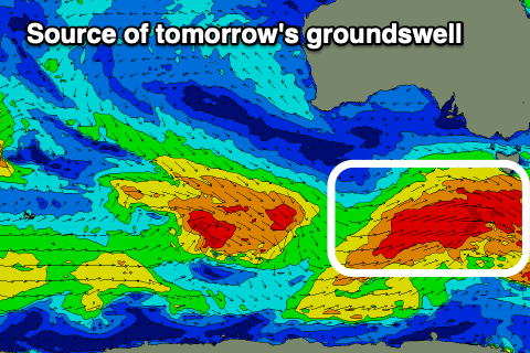
There’s no real change to tomorrow’s outlook, with a strong frontal system that’s currently moving across us due to bring a strong pulse of W/SW and SW swell energy that’ll peak early tomorrow to 4ft on the sets, easing back through the day. Conditions look great with a moderate to fresh N/NW’ly, tending NW mid-late afternoon.
The downtrend will be short-lived, with the next swell generating system due to move in quickly tomorrow and Friday, producing a fetch of stronger gale to severe-gale W/SW winds.
This will produce another strong pulse of W/SW-SW groundswell for Friday afternoon, kicking to 4-5ft but with strengthening SW winds owing to the swell generating front moving through.
Saturday will still be solid but easing with 4ft sets due under a fresh W/NW-NW breeze, favouring protected spots.

Yet another frontal system moving in Saturday will generate another pulse of swell for Sunday but it looks weaker and more west, likely coming in around 2-3ft and with less favourable W/SW tending SW winds, lingering into Monday as the swell eases.
One final significant polar front firing up on the polar shelf should produce a moderate + sized S/SW groundswell for Tuesday afternoon. With fetches of severe-gale to storm-force winds, we should see 4ft sets but with those lingering S/SW winds as a high sits west of us.
Following this, easing surf is due with cleaner conditions mid-week, ahead of some good new swell again later week. All in all it’s a jam packed period.


Comments
Another top notch write up thanks Craig.
My pleasure.