Fun weekend of easing swell
Southern Tasmnian Forecast by Craig Brokensha (issued Friday May 10th)
Best Days: Late today, tomorrow, Sunday morning, Thursday
Features of the Forecast (tl;dr)
- Easing S/SW groundswell tomorrow with N/NW tending variable winds
- Smaller Sun with N/NW tending fresh N/NE winds
- Moderate sized W/SW swell building late Wed, peaking Thu with W/NW winds
Recap
Wednesday's swell eased into yesterday with light morning S’ly winds, while today we’ve seen building levels of strong S/SW groundswell with early onshore winds that are now variable. The sets are strong and to 3-4ft but mostly straight.

Strong, straight sets this arvo
This weekend and next week (Apr 11 - 17)
This afternoon’s strong pulse of S/SW groundswell is due to ease back quickly through tomorrow, thanks to the rapid eastward movement of the polar low that generated it.
We should still see 2-3ft sets tomorrow morning, easing with N/NW tending variable winds.
Sunday looks smaller and down from 1-2ft with N/NW tending fresh N/NE winds.

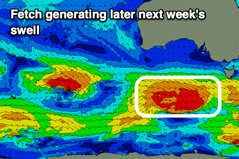
Looking into next week, and some weak but tiny W/SW swell is due Tuesday, followed by some better W/SW swell energy into Wednesday afternoon and more so Thursday.
Patchy but strengthening frontal activity under the country on Tuesday, passing under us Wednesday should see a fetch of strong to gale-force W/NW winds generated.
A good sized swell to 3ft is due on Thursday morning along with W/NW winds, easing Friday.
There may be larger swells to follow this but we’ll review this Monday. Have a great weekend!


Comments
The Clifton beach cam caught a good view of the Australis at 6:30