Strong swell for Friday with tricky winds
Southern Tasmania Forecast by Craig Brokensha (issued Wednesday May 8th)
Best Days: Keen surfers Friday, beaches Saturday morning, keen surfers Tuesday and Wednesday mornings
Features of the Forecast (tl;dr)
- Easing S/SW swell tomorrow with N/NW winds, shifting S/SW late AM
- Moderate sized S/SW groundswell buildung rapidly Fri with early variable winds, tending S then SE, possibly variable again into the PM
- Easing swell Sat with N/NW tending E/NE winds
- Smaller Sun with fresh N tending NE winds
- Building W/SW groundswell Wed, easing Thu with morning NW winds
Recap
A small lift in inconsistent groundswell came in around 2ft yesterday, while today our stronger pulse of S/SW groundswell filled in but with less favourable winds,, kicking to a stronger 3ft+ this afternoon.

Straight, bumpy sets this afternoon
This week and next (Apr 9 - 17)
This afternoon’s pulse of S/SW groundswell should ease back into tomorrow with sets still coming in around 3ft across Clifton along with better N/NW morning winds, shifting S/SW late morning with a shallow change owing to a trough.
Into Friday, our funky winds thanks to the trough lingering in the region look to make for tricky conditions along with the secondary strong pulse of inbound S/SW groundswell energy.

Winds might be variable at dawn, but increasing from the S during the morning and then SE, possibly going variable into the afternoon. All in all not great but workable.
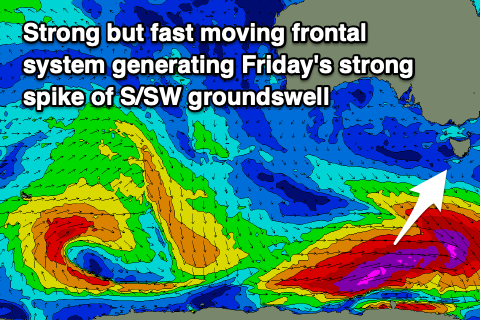
This strong secondary groundswell is being generated by a strong but fast moving polar low through our southern swell window, with a fetch of severe-gale to storm-force W’ly winds due to provide a rapid kick in size to 3-4ft during the day across Clifton.
The easing trend looks rapid with dropping 2-3ft sets on Saturday with great N/NW tending E/NE winds.
From here into early next week the trend remains small to tiny, with the next pulse of energy due mid-late week as a strengthening frontal system moves across us. More on this Friday.

