Low point in swell tomorrow, active from Wednesday
Southern Tasmanian Surf Forecast by Craig Brokensha (issued Monday April 1st)
Best Days: Thursday, Friday ahead of sea breezes, Saturday, Sunday morning
Features of the Forecast (tl;dr)
- Low point in swell tomorrow with N/NW tending strong S/SW winds late AM
- New mid-period W/SW swell and S/SW windswell Wed with strong SW winds
- Temp drop in swell Thu AM, building again into the PM, easing Fri
- N/NW tending variable winds Thu, N/NW Fri AM ahead of weak sea breezes
- Moderate sized SW groundswell building Sat with N tending strong E/NE winds
- Easing swell Sun with N/NE tending E/SE winds
Recap
Plenty of swell across Clifton though closing out on the morning low tides with surf to 2ft to occasionally 3ft Saturday, smaller yesterday and more back to 2ft.
Today was clean again but smaller and back to 1-2ft.

Straight but chunky sets Saturday AM
This week and weekend (Apr 2 - 7)
Tomorrow looks like a lay day as the swell continues to ease in size leaving tiny surf across Clifton with early N/NW winds ahead of a strengthening SW-S/SW change from later morning as a trough moves in from the west.
This trough will leave strong SW winds into Wednesday as some new mid-period W/SW swell energy arrives. This is being generated by pre-frontal W/NW winds moving in south of the country, with 2-3ft surf due Wednesday.
A temporary drop in swell is due Thursday morning ahead of a secondary, reinforcing pulse of mid-period W/SW swell arrives, generated by stronger, near-gale-force W/NW winds moving in through our swell window tomorrow.
A good pulse to 3ft+ is due through the afternoon, easing back from 2-3ft Friday morning with N/NW offshores ahead of weak sea breezes Thursday, similar Friday.

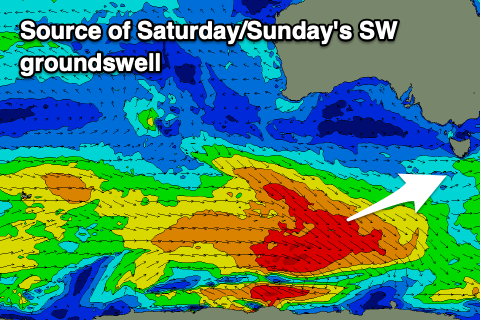
We'll then see a final pulse of groundswell from this progression of polar frontal activity, with a fetch of W/NW gales due to produce 3-4ft of swell for Saturday afternoon.
N'ly offshores should create clean conditions again Saturday morning, strengthening from the E/NE into the afternoon with Sunday seeing N/NE tending E/SE winds.
Longer term, the Southern Ocean storm track looks to remain overactive into next week, generating plenty of swell that looks to become medium in size with hopefully winds out of the western quadrant. More on this Wednesday.

