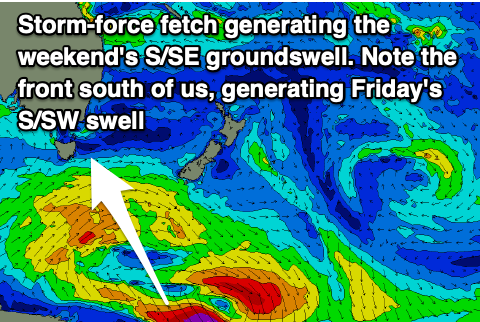
Upgrade in the weekend's S/SE groundswell
Southern Tasmanian Surf Forecast by Craig Brokensha (issued Wednesday March 13th)
Best Days: Tomorrow morning, possibly Friday morning, Saturday morning, Sunday, Monday
Features of the Forecast (tl;dr)
- Easing surf tomorrow with W/NW winds, tending SW mid-late AM, stronger S/SW into the PM
- New S/SW swell Fri with SW tending S/SE winds (possibly light W early)
- Moderate sized S/SE groundswell building Sat, peaking later, easing Sun
- NW tending S/SW then S/SE winds Sat, N tending gusty E/NE Sun
- Mix of swells Mon with strengthening N/NE tending NE winds
Recap
Monday's swell eased into yesterday, while today, some new, inconsistent W/SW swell energy has filed in with surf to 2ft this morning, a bit bigger this afternoon but with sea breezes.
This week and next (Mar 14 - 22)
Today's swell is due to ease back from the 2ft range tomorrow morning and winds look better, tending W/NW in the morning before shifting SW later morning and then strong S/SW into the afternoon.
This will be associated with a weak front pushing up past the corner of the state, bringing some new mid-period S/SW swell Friday to 2ft+.
Winds look to linger out of the SW Friday morning, with S/SE sea breezes. There's a chance for lighter W/NW winds early but keep an eye on the local winds observations.

Moving into the weekend and we've got our good sized S/SE groundswell due to build through Saturday, peak overnight and ease Sunday.
The fetch linked to this swell is forming south of New Zealand, with a more substantial area of severe-gale to storm-force S/SE winds on the cards.
With this, a strong pulse of swell is due, reaching 3-4ft across Clifton, easing from 3ft+ Sunday morning. Locations down the arm will be bigger again and winds should be light NW, tending S/SW and then S/SE on Saturday, N tending E/NE on Sunday.
The outlook for early next week then looks slow, with a trough bringing some weak S'ly windswell on Wednesday but with onshore winds. More on this Friday.

