Easing surf on the weekend, with new energy next week but with dicey winds
Southern Tasmanian Surf Forecast by Craig Brokensha (issued Friday March 8th)
Best Days: Tomorrow morning, Monday, selected spots Wednesday for the keen
Features of the Forecast (tl;dr)
- Easing swell Sat with strong N/NE winds, tiny Sun with early SW winds, tending variable then stronger S
- Strong W/SW groundswell for Sun PM with, easing Mon with N tending light SE winds
- Small Tue with strengthening S/SW winds
- Moderate sized mix of W/SW swells Wed with SW tending S/SE winds
- Easing swell Thu with SW tending S/SE winds
Recap
Yesterday was weak and windy, but our stronger swell for today has come in on forecast with sets to 2-3ft across Clifton under variable winds.
This weekend and next week (Mar 2 - 8)
The weekend will be small but fun, with today's swell due to ease back from 1-2ft tomorrow morning with tricky, strong N/NE winds that will favour some spots over others.
Sunday looks tiny, with a shallow SW change around dawn, tending variable ahead of freshening S'ly winds through the day.
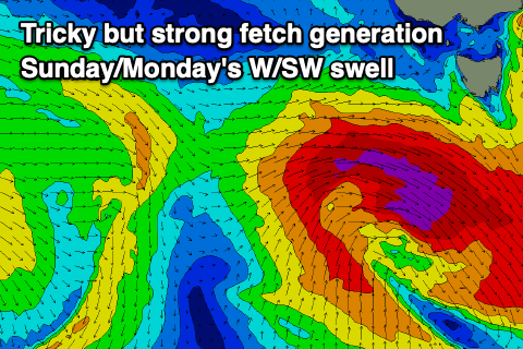
Later in the day, our strong but short-lived pulse of W/SW groundswell is due, generated by a strengthening mid-latitude low moving in from the west over the weekend.
The low will form early tomorrow morning and generate a tight, short-lived burst of severe-gale W/SW winds through our western swell window.

The fetch will be a little disorganised and with this, a slight downgrade in the expected size is due, with a late kick to 2-3ft due Sunday, easing from a similar size Monday morning.
Winds will be good on Monday with a light N'ly offshore due ahead of weak, variable sea breezes.
Tuesday looks smaller and back to 1-2ft or so, but our next pulse of W/SW groundswell should be seen later in the day, peaking Wednesday morning.
This will be generated by a healthy, slow moving polar low that's firing up to the east of the Heard Island region today.
A good fetch of severe-gale W/SW winds should produce inconsistent 3ft surf next Wednesday, with the remnants of the storm possibly generating more consistent mid-period levels of swell to 2-3ft.
Winds are dicey, with the swell producing storm bringing strong S/SW winds Tuesday, possibly lingering from the SW Wednesday. More on this Monday. Have a great weekend!

