Good surf days to come
Southern Tasmanian Forecast by Craig Brokensha (issued Monday March 4th)
Best Days: Today, tomorrow, Wednesday morning, Friday morning, Saturday morning
Features of the Forecast (tl;dr)
- Large, S'ly groundswell today, easing later, further tomorrow
- Moderate + sized S/SE swell tomorrow, easing with N tending S/SE winds from mid-PM, smaller Wed with N/NW tending SE winds, then S/SW-SW later
- Weak W/SW swell for Thu PM with W/NW tending SW then SE winds
- Better inconsistent W/SW swell Fri AM with NW tending SE winds
Recap
A solid mix of W/SW swells on Saturday to 3-4ft across Clifton with workable winds towards western ends, dropping temporarily into yesterday morning as we fell in between swells.
A strong onshore change kicked in around 8am yesterday and with it we saw building levels of localised SW windswell and SW groundswell energy with the surf becoming large later in the day.
This morning it’s still large and to 4-6ft across the region with favourable winds for more protected spots.
This week and weekend (Mar 5 - 10)
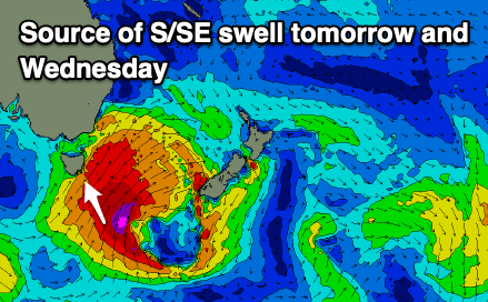
The significant low responsible for the current run of swell and cold weather is now just south-east of us, pushing onwards towards New Zealand.

On the backside of the low, fetches of severe-gale to storm-force winds from the S/SW to S/SE have generated some large, reinforcing levels of S-S/SE swell for this afternoon and tomorrow.
With this we should see Clifton maintaining 4-5ft surf through tomorrow, easing off later in the day and further from the 2-3ft range Wednesday. More exposed breaks further down the Arm are likely to be bigger.
Light to moderate N’ly winds are due tomorrow morning, giving into freshening S/SE sea breezes mid-late afternoon, with Wednesday seeing N/NW offshores ahead of a weak SE sea breeze and shallow S/SW-SW change through the later afternoon.
The cold front linked to this change should produce a small, weak pulse of W/SW swell for Thursday, reaching 2ft through the day, with W/NW winds likely, tending SW then SE.

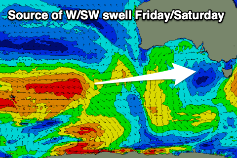
Into Friday, an inconsistent but better W/SW swell is due, generated by a healthy frontal progression firing up south-west of Western Australia yesterday and today, with the progression weakening while moving closer towards us through the rest of the week.
Good 2ft to possibly 3ft sets are due across Clifton in the morning, easing through the day with NW offshores ahead of SE sea breezes. Saturday will fade from 1-2ft but be clean in the morning again.
Longer term the outlook remains active into next week but with swells initially from the west again, more on this Wednesday.

