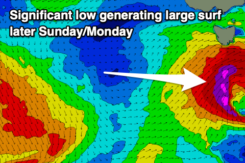
Very dynamic period ahead
Southern Tasmanian Surf Forecast by Craig Brokensha (issued Wednesday February 28th)
Best Days: Selected spots Saturday, Sunday and Monday, Tuesday morning, Wednesday morning
Features of the Forecast (tl;dr)
- Moderate sized mix of W/SW swells Saturday with gusty W/SW tending strong SW winds
- Large S/SW groundswell building later Sun with strong W/NW winds, shifting W/SW-SW into the PM
- Large, easing S'ly groundswell Mon with strong but easing S/SW tending S/SE winds later
- Moderate sized S/SE swell Tue, easing with N tending SE winds
Recap
Tiny surf yesterday which has continued into today.
This week and weekend (Feb 29 – Mar 3)
Tiny surf will continue into the end of the week, offering little runners for beginners, but into the weekend and early next week, our better sources of swell are still on track.
Firstly, a strong polar low that fired up in our far swell window, south-west of Western Australia has generated an inconsistent W/SW groundswell for Saturday that's on track to come in at 2-3ft Saturday.
Also in the mix will be some more consistent, closer-range energy generated by a secondary frontal system firing up on the tail of the low, passing under the country with strength over the coming days.

This looks to boost wave heights more to 3ft+ on Saturday, easing back Sunday morning to 2-3ft, but only temporarily.
This is because, a final but significant storm is due to fire up south-west of us on the weekend, that being a tight and intense low.
The low us due to project a fetch of severe-gale SW winds up through our south-western, then southern swell windows Sunday, producing a large spike of S/SW swell through the day, reaching 6ft near dark across Clifton, easing back from a similar size Monday morning.
The backside of the low should produce fun levels of easing S/SE swell into Tuesday to 3-5ft or so, smaller Wednesday.
Looking at the local winds and gusty W/SW tending strong SW winds are still on the cards for Saturday, not ideal, with strong W/NW winds Sunday morning, shifting near gale-force W/SW-SW into the afternoon/evening.
Strong S/SW winds will persist into Monday, easing and tending more S/SE later, with Tuesday seeing offshore N'ly winds.
All in all it'll be a tricky round of swell to negotiate but with plenty of options.

