Good but onshore swell tomorrow, fading fast Sunday
Southern Tasmanian Surf Forecast by Craig Brokensha (issued Friday February 23rd)
Best Days: This afternoon, Sunday morning, Tuesday, Wednesday and Thursday mornings
Features of the Forecast (tl;dr)
- Moderate sized SW swell tomorrow AM, easing with strong W/SW tending SW then S/SE winds
- Fading swell Sun with N/NW winds, tending light S and then variable
- Small to tiny, inconsistent W/SW swell from Mon PM through Thu
- Gusty SW winds Mon, N/NE tending strong E/NE Tue and Wed
- Better swells on the way from later next week
Recap
The swell bottomed out yesterday, while today we've seen a tiny swell this morning, building further into this afternoon as a strong low moves across the state.

2ft sets this afternoon
This weekend and next week (Feb 24 – Mar 1)
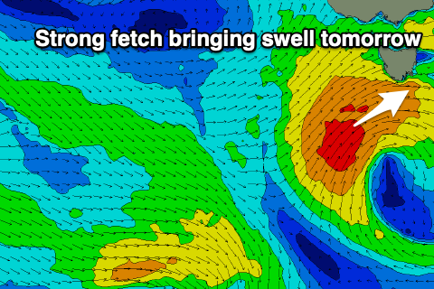
This afternoon's increase in swell which is now 2ft should build further overnight and peak tomorrow morning, generated by a strong mid-latitude low moving across us. A fetch of strong to gale-force SW winds should now kick up 3-4ft sets tomorrow morning but conditions will be average and best in selected spots with a strong W/SW tending SW then S/SE breeze.

Sunday still looks the pick with fading 1-2ft sets and a light N/NW offshore ahead of a possible shallow, mid-morning change, variable again into the afternoon.
Most of early to mid-next week looks small to tiny, with background levels of mid-period W/SW swell building Monday and holding through Thursday to 1ft to possibly 2ft.
Monday will be poor with gusty SW winds, cleaner Tuesday under a N/NE tending stronger E/NE breeze, similar Wednesday.
As touched on in Wednesday's update, the longer term outlook is very active with the Southern Ocean storm track due to fire up through next week and into next weekend, bringing a moderate + sized run of swell with what looks to be periods of favourable winds. More on this Monday. Have a great weekend!

