Small swells continue with varying winds
Southern Tasmanian Surf Forecast by Craig Brokensha (issued Monday February 12th)
Best Days: Tomorrow morning, Thursday and Friday mornings
Features of the Forecast (tl;dr)
- Easing swell tomorrow with dawn N tending light S winds, freshening from the S/SE
- Weak SW windswell Wed with strong W/SW-SW winds
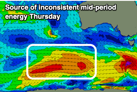
- Less consistent, reinforcing mid-period W/SW swell Thu and Fri with NW tending light SE winds
- Small-mod sized, inconsistent S/SE groundswell building Sun with W/SW-SW winds, easing Mon with similar winds
Recap
Large surf again for Saturday with favourable morning winds for protected spots, easing back from a still solid 3ft yesterday morning with a light offshore wind.
This morning was still clean and a fun 2ft with a reinforcing pulse of SW swell in the water.
This week and weekend (Feb 13 - 19)

Today's reinforcing pulse of swell is due to ease back tomorrow from the 2ft range though winds are a touch funky. A dawn N'ly is due to shift light S but then variable during the morning before freshening into afternoon.
A weak front moving across us Wednesday will bring with it a temporary kick in windswell to 2ft or so on the sets but with strong W/SW-SW winds.
Thursday should see this swell fade, with some inconsistent, background energy from the earlier stages of the front offering slow 1-2ft sets for the keen.
Conditions will be much cleaner with a N/NW offshore, tending SE into the afternoon but without too much strength, similar Friday both swell and wind wise.

The weekend looks tiny on Saturday, but another pulse of S/SE groundswell is on the cards for Sunday afternoon and Monday morning, generated by a robust fetch of gale to severe-gale S/SE winds on the polar shelf Thursday.
This swell looks to be a touch stronger than that seen last week, with a good kick to 3ft+ due Sunday afternoon but with W/SW winds, easing Monday from 3ft with similar W/SW-SW winds. Not ideal.
These average winds will be brought on by a front moving up past us, bringing some localised swell. More on this Wednesday.

