Strong swells to come this period
Southern Tasmanian Surf Forecast by Craig Brokensha (issued Wednesday January 31st)
Best Days: Tomorrow morning. selected spots Friday, Saturday, Sunday morning
Features of the Forecast (tl;dr)
- Easing swell tomorrow with N/NW tendinjg gusty W/SW winds
- Large, building W/SW tending SW swell Fri, peaking in the PM with strong W/SW winds
- Rapidly easing SW swell Sat with N/NW tending N/NE then SE winds
- Reinforcing, moderate sized W/SW groundswell for Sun, peaking in the PM with variable tending SE winds
Recap
Yesterday saw a small pulse of W/SW energy to 1-2ft while today there's more size but with less than ideal conditions and winds.

Solid but onshore today
This week and weekend (Feb 1 - 6)
Today's kick in swell was generated by a strong but fast moving low moving under us yesterday, but the size will fade quickly as a result. It'll be clean but fading from 1-2ft tomorrow with a N/NW offshore, shifting strong W/SW into the afternoon as the next swell generating system moves in.
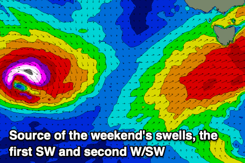
This secondary strengthening frontal system and a third low firing up behind it are being influenced by a strong upper level jet (enhanced jet stream) sitting just south of Western Australia.
Any storm moving into this area is being supercharged and we'll see this later this continuing this week and weekend.
Looking at Friday's system, and this will develop to the south of the Bight today, with a strengthening fetch of W'ly gales due to project east and then north-east through our western and then south-western swell windows while pushing up and across us Friday.
This will bring a steep, rapid increase in large W/SW tending SW swell through Friday, building from 3ft to possibly 4ft in the morning to a large 6ft into the late afternoon along with strong W/SW winds.

Saturday will see conditions clean up rapidly as the next approaching low from the west tips winds to the N/NW in the morning, N/NE late morning and then weak sea breezy.
The swell will ease rapidly thanks to the rapid transition of the first frontal system to the east, with large but easing surf from the 4ft range out of a more S/SW direction.
The next low will be a 'bombing' system, generated with the catalyst for it being the remnants of Tropical Cyclone Anggrek in the Indian Ocean being absorbed into the westerly storm track, and then deepening significantly with the help of the upper jet.
This low is forecast to develop south of Western Australia, tracking east-southeast while generating a fetch of storm-force W'ly winds.
The direction will be W/SW on Sunday but a moderate sized groundswell should build back to the 4ft range during the day but with variable winds that might be light onshore.
We'll have a closer look at this on Friday.
Following this the outlook is slower so make the most of the coming surf days.


Comments
Autumn bomb swell is way early..
true dat... 16seconds...