Active period of swell
Southern Tasmanian Surf Forecast by Craig Brokensha (issued Monday January 29th)
Best Days: Thursday morning, Saturday, Sunday morning
Features of the Forecast (tl;dr)
- Moderate sized spike in W/SW swell Wed with fresh W/SW tending strong S/SW-S/SE winds
- Fading swell Thu with NW tending W/SW winds
- Large W/SW-SW swell building later Fri with strong W/SW winds
- Easing swell Sat with NW tending E/NE winds
- Reinforcing, moderate sized W/SW groundswell for Sun PM with N tending S winds
Recap
Tricky levels of W/SW swell on the weekend with Sunday coming in better than Saturday when the best pulse of energy was due. Conditions were nice and clean both days with favourable winds.
Today the swell has faded with tiny waves for beginners.
This week and weekend (Jan 30 – Feb 4)
As touched on in last week's update, the coming period is tricky with lots of frontal activity due to move in from the west, but there's been an improvement in the strength and position of these systems.

Each one looks to grow stronger and stronger, generating plenty of tricky swell pulses for the coming period.
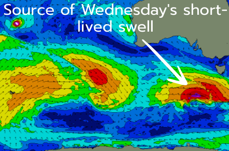
The first is currently moving in from the west, with it due to strengthen while south-west of us tomorrow. A tight fetch of gale to severe-gale W/SW winds should generate a small pulse of groundswell for Wednesday afternoon, pulsing to 2-3ft across Clifton.
Unfortunately the swell generating front will move through at the same time, with fresh W/SW breezes due Wednesday morning, strong S/SW tending S/SE into the afternoon.
The swell will ease quickly into Thursday back from 1-2ft with favourable NW winds, shifting W/SW into the afternoon with the next system.
This next system looks to be quite significant with a strengthening low directly under us on Thursday evening and Friday due to project a fetch of W/SW tending SW gales up and across us.
This will kick up some localised W/SW tending SW swell on Friday with associated, strong W/SW winds, reaching 4-5ft+ into the late afternoon, easing from 4-5ft on Saturday.

Winds should improve and tend W/NW on Saturday morning, then N/NE and E/NE into the afternoon as the swell eases rapidly.
Following this, another strong swell producer is due to move in, that being a 'bombing low' spawning off the remnants of Tropical Cyclone Anggrek which is currently in the Indian Ocean.
Storm-force W'ly winds look to produce a moderate sized W/SW groundswell for Sunday afternoon, easing Monday.
At this stage we're probably looking at sets to 3-4ft across Clifton but more on this Wednesday as there's a bit to digest.

