Dynamic week ahead
Southern Tasmanian Surf Forecast by Craig Brokensha (issued Monday January 15th)
Best Days: Tomorrow morning before the swell fades, Thursday, possibly Saturday morning and Sunday morning
Features of the Forecast (tl;dr)
- Fading swell tomorrow with strengthening N/NE tending E/NE winds
- Tiny Wed with strong N/NE tending NE winds
- Late increase in small, mid-period SW swell Wed, peaking Thu with N/NW-N/NE winds
- Weak, building S/SW windswell Fri with strong W-W/SW winds
- Mix of swells for the weekend with W/SW-SW winds (likely W/NW early)
Recap
Poor surf on Saturday but yesterday morning offered a window of lighter winds and new mix of swells to a peaky 2ft+ for the keen.
Today the swell was nice and clean, hanging in the 2ft+ range with variable winds but strong onshores have ruined it this afternoon.

Good surf this morning
This week and weekend (Jan 16 - 21)
The current swell is on the way out and looks to continue to ease through tomorrow, back from a slow 1ft to maybe 2ft as winds strengthen from the N/NE tending E/NE.
This increase in wind will be ahead of a deepening mid-latitude low moving in from the west, fuelled by a polar front projecting up from the Southern Ocean, merging with it.
The low is expected to stall off our west coast through Wednesday and Thursday, with strong N/NE tending NE winds feeding into it on Wednesday, while the low will start moving east across us Thursday, bringing varying N/NW-N/NE winds.

Swell wise, the polar front should generate a fun pulse of swell for later Wednesday but more so Thursday morning to 1-2ft.
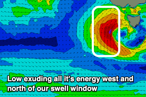
The low itself unfortunately will exude all its energy west and north of our swell window, with just a weak windswell likely on Friday afternoon as the backside of it brings strong W tending W/SW winds.
From the weekend, a persistent flow of W/SW-SW winds are due across the state as a weak polar front projects towards us, but then stalls into a stationary system south of us while strengthening.
The stalling frontal activity should bring building levels of swell later in the weekend but more so next week but with dicey winds. More on this dynamic outlook Wednesday.

