Poor weekend, better early next week
Southern Tasmanian Surf Forecast by Craig Brokensha (issued Friday January 12th)
Best Days: Monday morning, selected spots Tuesday morning
Features of the Forecast (tl;dr)
- Strong S/SW-SW winds tomorrow
- Mod-fresh W/SW tending strong S/SW winds Sun with a building SW swell
- Easing S/SW swell Mon with N/NW tending SE winds
- Fading surf Tue with strong N/NE tending E winds
- Strong S winds Wed and Thu with a localised S windswell
Recap
The small W/SW swell energy provided inconsistent, fun waves for fuller volumed boards on the big morning tides yesterday and today, choppy into the afternoons.

Fun sets this AM with NCO
This weekend and next week (Jan 13 - 19)
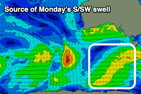
The weekend ahead still looks poor as a weak polar frontal system pushes up and into the state early tomorrow, bringing strong S/SW-SW winds, possibly tending back W/SW for a period Sunday morning before reverting back to the SW mid-morning.
The frontal system should generate some fun swell though, peaking through Sunday afternoon but Monday should still see 2ft+ sets as winds ease and tend light N/NW.

This is the day so surf with afternoon sea breezes spoiling conditions after lunch. Tuesday will be smaller (1ft to maybe 2ft) and strengthening N/NE winds will limit surfing options, tending E into the afternoon.
The downwards trend will continue into Wednesday morning, but the next swell producing system and associated frontal change looks to bring strong S'ly winds.
The front is expected to spawn a low in our vicinity, with poor, cold, stormy conditions due to persist next Thursday, with onshore winds abating Friday.
So with this in mind make the most of Monday. Have a great weekend!

