Small waves for the coming days, poor on the weekend
Southern Tasmanian Surf Forecast by Craig Brokensha (issued Wednesday January 10th)
Best Days: Today, tomorrow later morning ahead of sea breezes, Friday morning, Tuesday morning
Features of the Forecast (tl;dr)
- Small, inconsistent levels of W/SW swell for Thu, building through the day, peaking Fri, easing Sat
- N/NW-NW winds Thu AM ahead of sea breezes, variable W/NW tending weak S/SW then fresh S/SE Fri
- Strengthening SW winds Sat, W/SW-SW tending SW Sun
- New, weak SW swell for Sat/Sun with S winds Sun
- Fun S/SW swell Mon but with lingering SW winds
- Fading surf Tue with N/NW winds
Recap
Lingering onshore winds in the wake of a trough on Wednesday evening created average surf yesterday, cleaner today with a fun mix of easing SE and SW swells to a full 2ft this morning. Conditions were clean and remain so this afternoon with freshening winds ahead of an approaching trough.

High tide but fun this AM
This week and weekend (Jan 11 - 14)
The trough linked to today's increasing winds will move through quickly, with offshore winds due to kick back in tomorrow morning from the N/NW-NW.
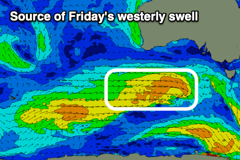
A new, inconsistent mid-period W/SW swell should build with it possibly a little undersized early but building to 1-2ft through the day, followed by a secondary similar sized pulse on Friday.
The source of these swells is a healthy series of cold fronts moving through our western swell window, from the south-west of WA since the weekend.

Friday's pulse looks most consistent but winds are a touch dicey.
A dawn W/NW breeze is due to swing S/SW but only light mid-morning with a shallow change, freshening from the S/SE into the afternoon.
Moving into the weekend, and a weak polar front pushing up and across the state looks to bring a strong, dawn SW change Saturday, persisting from the W/SW-SW on Sunday morning.
The front itself should generate some fun SW swell to 2ft+ Sunday but with the poor winds, easing from 2ft on Monday morning and from the S/SW.
There's a chance winds hold from the W/SW-SW on Monday with cleaner conditions on Tuesday but with fading 1-2ft sets max.
A secondary, stronger polar front may generate a better S/SW swell for mid-late next week though winds again look to be an issue, cleanest as it eases. More on this Friday.

