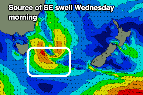
Small SE swell for Wednesday, followed by W/SW pulses
Southern Tasmanian Surf Forecast by Craig Brokensha (issued Monday January 8th)
Best Days: Wednesday morning, Thursday morning, Friday morning, Monday morning
Features of the Forecast (tl;dr)
- Small mix of swells tomorrow with moderate, easing S/SE winds, freshening into the PM
- Fun SE swell for Wed AM, bigger down the Arm with light N/NW winds ahead of sea breezes
- Small, inconsistent levels of W/SW swell for Thu, Fri, easing Sat
- N/NW winds Thu AM ahead of sea breezes, variable W/SW Fri AM ahead of sea breezes
- Strengthening SW tending S/SW winds Sat
- New, weak SW swell for Sat/Sun with S winds Sun, N/NW Mon AM
Recap
Fun waves each morning on the weekend with background levels of swell to 1-2ft.
Today is poor with strong onshore winds in the wake of a trough moving through.
This weekend and next week (Jan 6 - 12)
The trough linked to today's change is still on track for form a low pressure centre today, but it will move off quickly to the east tomorrow, with no major swell generating properties besides a small pulse out of the SE Wednesday morning.
A moderate S/SE wind is due to become lighter through the morning tomorrow but with small surf it's not worth worrying about.

Better winds are due Wednesday morning out of the N/NW and with 2ft sets out of the SE (bigger down the Arm), easing through the day.
Into the second half of the week, some small, mid-period W/SW swell is expected, generated by a relatively weak but persistent frontal progression moving in from the west.
Fetches of W winds should generate 1-2ft surf from Thursday through Friday (strongest), easing Saturday.
N/NW winds are due on Thursday morning ahead of sea breezes, with variable W/SW breezes Friday morning ahead of sea breezes.
Longer term, small pulses of SW swell look to persist from generally weak polar frontal activity.
A weak front should generate a small 1-2ft of swell for Sunday/Monday, cleanest on the latter but we'll review this on Wednesday.

