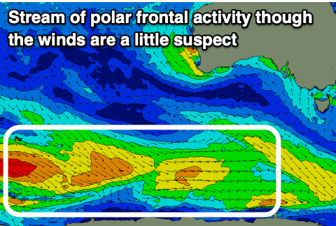
Plenty of swell but with average winds
Southern Tasmanian Surf Forecast by Craig Brokensha (issued Monday December 18)
Best Days: Saturday morning
Features of the Forecast (tl;dr)
- Moderate sized W/SW groundswell building Tue with a strong SW tending S/SW winds, easing Wed with fresh SW winds, tending S
- Fading swell Thu with variable S winds ahead of sea breezes
- Building mid-period SW swell Fri PM with N/NE tending strong E/NE winds
- Peak in swell Sat with N tending S/SE winds
- Strengthening S winds Sun, holding Mon, easing slowly Tue
- Poor S windswell Sun PM through Tue
- Moderate sized mid-period WSW swell for next Tue
Recap
Slow but fun waves all weekend with mid-period swell to 1-2ft, tiny today.
This week and weekend (Dec 19 - 24)
The coming forecast period and beyond is very active thanks to a stream of polar frontal activity moving in from the Heard Island region for the coming fortnight.
Late last week, the first and strongest of all the swell generators fired up, generating an inconsistent W/SW groundswell for tomorrow that's due to peak through the afternoon to 2-3ft, easing from 2ft on Wednesday.
Unfortunately our forecast onshore winds are on track thanks to a trough moving in this evening.

This will see strengthening S/SW winds firing up from dawn tomorrow, holding out of the SW Wednesday morning as the swell eases (S'ly into the afternoon).
Thursday is a touch dicey but we're likely to see light, lingering S winds going variable but with tiny, fading surf.
Moving into Friday/Saturday, our first pulse of mid-period swell from the secondary polar activity is due with strengthening N/NE tending E/NE winds and building sets to 2ft due later Friday, peaking Saturday to a similar size.
Conditions look better Saturday with N'ly morning winds ahead of S/SE sea breezes.
We've got a stronger low due to move in late week and on the weekend, producing a better pulse of swell for Tuesday, but it looks like another trough will bring strengthening S winds through Sunday afternoon, holding Monday and Tuesday, creating poor conditions. Some decent S'ly windswell will also be kicked up but with no quality to be found.
Longer term onshore winds look to linger so while we've got swell, clean conditions will be tricky to find.

