Plenty of swell for the period with varying winds
Southern Tasmanian Surf Forecast by Craig Brokensha (issued Wednesday December 13)
Best Days: Thursday, Friday, Saturday, Sunday morning, Wednesday morning
Features of the Forecast (tl;dr)
- Moderate sized, reinforcing SW groundswell tomorrow (possibly undersized early) with W/NW winds, strengthening from the NW ahead of a late PM W change
- Easing swell Fri with W/NW tending variable winds
- Small mix of mid-period SW swell Sat, W/SW Sun with N/NW tending W winds Sat, N/NW Sun AM ahead of sea breezes
- Moderate sized W/SW groundswell building Tue with a strong S change, easing Wed with variable morning winds
Recap
Large, strong surf yesterday morning with clean conditions before sea breezes kicked in, only surfable at selected spots.
This morning was more manageable with easing 3ft sets under favourable winds though sea breezes are now in again across the coast.

Straight, solid sets this AM
This week and weekend (Dec 14 - 17)
With the large swell from yesterday on the ease, we look to the next pulse of groundswell due tomorrow across the state. This was generated by a tighter, smaller but similar in strength polar low that fired up on the tail of the broader system on the weekend, and we should see strong 3ft+ sets across Clifton
The swell might be a touch undersized at dawn but in by mid-morning and winds look favourable early and W/NW, strengthening from the NW ahead of a late afternoon W change.
This will be as a strengthening front moves across us, adding some small windswell to the event.
An easing mix of swells are due Friday from 2ft under light W/NW winds, tending variable.
Small pulses of mid-period SW and W/SW swell are on the cards for the weekend, with the best angled due Saturday.
These are being generated by back to back, weak fronts moving through the Southern Ocean, the strongest tracking a little further north than the initial.
2ft surf is generally expected, SW in direction on Saturday and W/SW on Sunday, easing Monday.

Conditions look clean Saturday morning with strong N/NW tending W winds, N/NW on Sunday morning ahead of sea breezes.
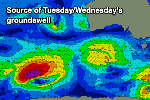
Looking at next week, and a better but inconsistent W/SW groundswell is due Tuesday afternoon, easing Wednesday. The source is a strong polar low firing up around the Heard Island region tomorrow morning, generating a fetch of severe-gale to possibly storm-force W/SW winds in our far swell window.
The swell should peak late Tuesday to 2-3ft but a trough looks to bring a strong S change, cleaner on Wednesday morning as the swell eases.
Longer term the Southern Ocean storm track remains active, generating small pulses of swell. More on this Friday.


Comments
Great info , keep up !!!.
Thanks Badger!