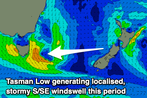
Stormy S/SE windswell for the weekend
Southern Tasmanian Surf Forecast by Craig Brokensha (issued Friday November 24)
Best Days: Tuesday morning, Wednesday morning
Features of the Forecast (tl;dr)
- Tiny tomorrow AM ahead of a late pulse of moderate sized S/SW groundswell, peaking Sun AM
- Light S winds (possiby variable), strengthening from the S through the day
- Moderate sized stormy S/SE swell building Sun with strong S/SE winds
- Easing S/SE swell Mon with strong S/SW winds, easing
- Easing small mix of swells Tue with variable tending S/SE winds
- Small mid-period SW swell for Tue PM, peaking Wed AM with NE tending strong E/NE winds
Recap
Light onshore winds yesterday with 2ft of swell, cleaner this morning with the swell continuing into the 2ft range. Sea breezes have since kicked in creating choppy conditions.
This weekend and next week (Nov 25 – Dec 1)
Looking at the weekend ahead and we've got a deepening trough that's due to move east and strengthen to the south-east of the state during Sunday.
This will bring strengthening S'ly winds tomorrow afternoon, light in the morning and possibly variable for a period though with tiny 1ft+ leftovers,

Come Sunday, stronger S'ly winds are due associated with strong S/SE winds spinning around the low to our south-east, and this will generate a mix of building windswell and mid-period energy Sunday, reaching 4-5ft into the afternoon.
There'll also be a strong S/SW groundswell in the mix generated by a polar low that's to the south-west of the state but this will be hard to discern under the localised S/SE swells.
Come Monday the Tasman Low will start migrating to the east and this will see the S/SE swell easing back in size from the 3-4ft range but with strong S/SW winds, easing back to moderate to fresh through the day.
Lighter, more variable winds are due Tuesday morning but the swell will be back to 1-2ft.
Into Tuesday afternoon and more so Wednesday morning a fun pulse of new mid-period SW swell is due, generated by a polar fetch of strong to gale-force W/NW-NW winds firing up to the east of the Heard Island region today.
Small 1-2ft sets are due across Clifton, along with NE tending strong E/NE winds.
Longer term there's nothing too significant on the cards swell wise due to blocking high pressure. Therefore check the North East Forecaster Notes for more options. Have a great weekend!

