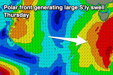
Large, windy swell this week, good into the weekend
Southern Tasmanian Surf Forecast by Craig Brokensha (issued Monday October 23rd)
Best Days: Thursday, Friday, Saturday, Sunday
Features of the Forecast (tl;dr)
- Tiny tomorrow with strengthening N winds
- Mod-large S/SW swell building Wed with early W/NW winds, tending strong W/SW mid-AM then SW
- Large mid-period S'ly swell Thu, peaking in the PM with strong SW tending S/SW winds
- Easing S swell Fri with W/NW tending weak SE winds
- Easing S swell Sat with N-N/NE winds
- Fun S/SE groundswel Sun with N winds
Recap
Saturday started cleaner than expected and with 2ft peaks for the keen, deteriorating as the day progressed with strengthening E'ly winds.
Sunday dawned clean as expected with some fun E/SE-SE swell coming in at 2ft+ before sea breezes kicked in late morning.
Today we're on the backside of the low generating the E/SE-SE swell with onshore winds and weak 2ft sets.
This week and weekend (Oct 24 - 29)
Tomorrow should become tiny with the swell bottoming out under strengthening N'ly winds ahead of an approaching trough.
This trough is due to form into a low pressure system directly west of us tomorrow before moving across us Wednesday, bringing a strong W/SW tending SW change shortly after dawn.
With this, a fetch of S/SW gales are forecast to be projected into us, kicking up a moderate-large mix of mid-period S/SW swell and localised windswell.

A spike to 4-6ft is likely by dark Wednesday while a secondary polar fetch of strong to gale-force S/SW winds will generate a larger S'ly swell for Thursday to 6ft, peaking into the afternoon.
This will be with strong SW tending S/SW winds, backing off and tending W/NW Friday morning with easing 4-5ft sets, smaller and easing from 2ft to possibly 3ft Saturday morning.
Afternoon sea breezes are due Friday but without much strength, clean Saturday with N-N/NE winds.
Into Sunday/Monday some good S/SE groundswell is on the cards, generated on the backside of the front bringing Thursday's large surf, with fetches of gales firing up in our south-eastern swell window. A pulse to 2-3ft is likely Sunday but we'll look at this closer on Wednesday.
Longer term some small W/SW swell is due next week but more on this Wednesday.

