Upgrade in the swell due mid-week
Southern Tasmanian Surf Forecast by Craig Brokensha (issued Monday October 16th)
Best Days: Tomorrow morning, Wednesday morning, Thursday morning
Features of the Forecast (tl;dr)
- Easing mix of swells tomorrow with NW tending E/NE winds
- W/SW swell for Wed AM, with a stronger SW groundswell building into the PM. N tending fresh S/SE winds
- Easing SW swell Thu with N tending weaker S/SE winds
- Fun reinforcing SW swell Fri with W/SW tending strong S/SW winds
Recap
Great conditions Saturday morning with 2ft to occasionally 3ft of swell hanging in the mix, becoming wind affected and choppy into the afternoon with strengthening winds.
Yesterday provided solid surf to 3-4ft that overpowered Clifton with great conditions but straight closeouts.
This morning the swell was easing back from 3ft with favourable conditions though straight surf early ahead of a strong onshore change.
This week and weekend (Oct 17 - 22)
Today's change is linked to a trough pushing in from the west, and with it some additional windswell is being added to the mix of groundswell, with both due to ease through tomorrow.
2-3ft sets are due across Clifton early, down to 1-2ft through the afternoon.
Winds look favourable and NW in the morning, ahead of E/NE sea breezes.
Into Wednesday and Thursday we've got an upgrade to the incoming swell which was flagged as quite sizey early last week, but the models backed off the swell producer into the end of the week.

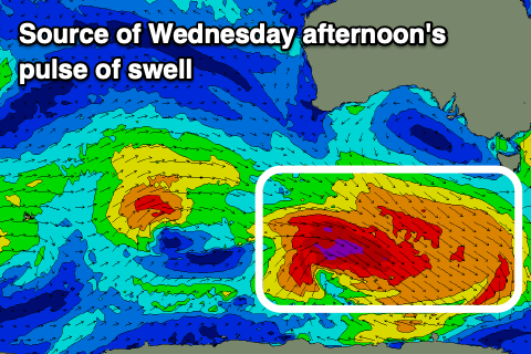
Well, we've had an upgrade on the weekend and we should see a strong polar low that's currently forming to the south-southwest of Western Australia, generating a fetch of W/NW-NW gales, followed by severe-gale W/NW winds.
A moderate sized SW groundswell should result from this fetch, with building surf Wednesday out of the W/SW initially to 2ft, pulsing to 3-4ft into the afternoon and evening before easing from 2-3ft on Thursday morning.
N winds will give into fresh S/SE sea breezes on Wednesday as the swell builds, with similar winds due Thursday. So target the mornings for a surf over the coming days.
A small, trailing low forming on the tail of the polar system is due to generate a small, reinforcing pulse of SW swell for Friday morning maintaining 2ft surf, easing back into the afternoon and smaller on the weekend.
Winds are funky for Friday as a trough moves in bringing deteriorating conditions with an early W/SW breeze that's due to go strong S/SE through the day.
Looking at the weekend and the trough bringing Friday's change looks to deepen into a low and stall in the region west of the state.
We may see some localised windswell when it moves across us but the models are divergent on the timing, intensity and specifics so check back here on Wednesday for the latest.

