Slower period as the swell sources dry up
Southern Tasmanian Surf Forecast by Craig Brokensha (issued Monday August 28th)
Best Days: Tomorrow ahead of sea breezes, Saturday
Features of the Forecast (tl;dr)
- Easing S swell tomorrow
- Inconsistent W/SW groundswell building through the day, easing Wed
- N/NW tending S/SE winds Tue, W/SW-SW Wed, freshening into the PM
- Tiny Thu with N/NW winds ahead of a late change
- Inconsistent mid-period W/SW swell arriving late Thu, peaking Fri, easing slowly Sat
- Fresh SW winds Fri, N tending fresh NE Sat
- Stronger N/NE winds Sun
Recap
Plenty of size on Saturday but with onshore winds as SW swell energy from a significant low forming south-west of us on Friday peaked.
Yesterday a stronger S'ly swell filled in with light, workable winds and sets to 3-4ft.
This swell cleaned up this morning and was on the ease from 2-3ft.
This week and weekend (Aug 29 – Sep 3)
The current S'ly swell from the strong, slow moving low that moved under us Friday will fade tomorrow, while some new, inconsistent W/SW groundswell is due to take its place.
This was generated by healthy bursts of W/NW gale to severe-gale-force winds tracking along the polar shelf late last week, with inconsistent 2ft sets due to persist tomorrow, easing from a similar size Wednesday morning.
There's a chance it could be a little undersized at dawn tomorrow, with a morning N/NW breeze due to give into weak S/SE sea breezes, while Wednesday looks dicey as a front clipping is leaves W/SW-SW winds, freshening into the afternoon.

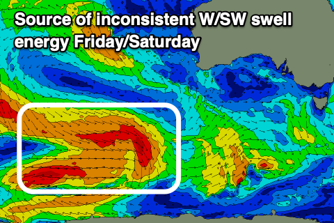
Thursday morning looks tiny, but later in the day we may see some new, acute, mid-period W/SW swell filling in, peaking through Friday.
This will be generated by a relatively weak but persistent frontal progression moving in from the west, bringing with it a weakening fetch of strong to gale-force W'ly winds.
This should produce some small W/SW swell peaking Friday to 2ft, with smaller, slower 1-2ft sets on Saturday.
Winds unfortunately look onshore out of the SW on Friday as the swell generating progression moves under us, with N tending fresh NE winds due on Saturday. Stronger N/NE winds are due on Sunday but with tiny, fading surf.
Longer term there's nothing too major on the cards with the storm track focussing up towards Western Australia late week. This will produce a W'ly groundswell for us early next week but with no size. More on this Wednesday.

