Strong west swells inbound
Southern Tasmanian Surf Forecast by Craig Brokensha (issued Monday August 21st)
Best Days: This afternoon, early tomorrow, Wednesday, Thursday, Friday morning, early Saturday, Sunday
Features of the Forecast (tl;dr)
- Small-moderate sized W/SW swell persisting tomorrow and Wed AM
- Stronger, moderate sized W'ly groundswell kicking Wed PM, with a secondary W/SW pulse Thu AM, easing
- N/NW winds, giving into a S/SW change mid-morning tomorrow
- N/NW tending W/NW winds Wed, fresh N/NW Thu
- Strong pulse of W/SW groundswell Fri PM with W/NW tending W/SW winds
- Secondary pulse of moderate sized W/SW groundswell Sat with W/NW tending SW winds mid-AM
- Easing swell Sun with variable NW tending SE winds
Recap
A good kick in swell through Saturday with 2ft waves across Clifton with workable winds, cleaner yesterday and persisting around 2ft.
This morning was a little slow but this afternoon we've got some new swell and clean conditions with sets to 2ft across Clifton.

New swell this arvo
This week and weekend (Aug 22 - 27)
This afternoon's increase in inconsistent W/SW swell should be followed up by a secondary pulse tomorrow, generated by a strong Southern Ocean frontal progression that fired up between the Heard Island region and Western Australia on the weekend.
Sets to 2ft should persist but early N/NW winds will give into a trough and S/SW change mid-morning.
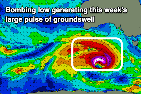
Of greater significance is a 'bombing low' forming to the south-west of Western Australia today. That being a low dropping rapidly in surface pressure, at least 24hPa in 24 hours. We'll actually see this low drop 40hPa within 24 hours, from 979hPa early this morning to 939hPa tomorrow morning.

With such a rapid drop in central pressure, we'll see severe-gale to storm-force W/NW-W/SW winds winds forming around the core of the low as it tracks east-southeast through our swell western window and broadens in scope.
This will result in a large spike of W'ly groundswell that looks to arrive Wednesday afternoon, with some better aligned W/SW groundswell energy for Thursday morning.
Ahead of the swell, Wednesday morning looks to be 2ft, with the W'ly groundswell arriving into the afternoon and pulsing to 3ft on the sets.
Thursday morning looks to be similar in size, if more 3ft to occasionally 4ft early, easing steadily through the day.
Winds on Wednesday look favourable and N/NW tending W/NW with Thursday seeing gusty N/NW winds persisting all day.
Following Wednesday/Thursday's swell, we're looking at a secondary strong, significant frontal progression firing up directly west-southwest of us through Thursday.
This is forecast to generate fetches of severe-gale W/SW winds, producing another moderate sized W/SW groundswell for late Friday but more so Saturday.
We're looking at a spike back to 3ft late Friday with Saturday seeing 3-4ft sets, easing through the day.
Local winds look less favourable though with a W/NW tending W/SW breeze due on Friday, early W/NW again Saturday morning before shifting SW mid-morning in the wake of the swell generating fronts.
We'll confirm this on Wednesday though. Easing surf is expected Sunday and Monday with favourable morning winds ahead of the next episode of swell early next week from strong polar frontal activity. More on this in the coming days.

