Fun waves with favourable winds
Southern Tasmanian Surf Forecast by Craig Brokensha (issued Friday August 18th)
Best Days: Every day this period besides Tuesday
Features of the Forecast (tl;dr)
- Moderate sized mid-period W/SW swell tomorrow, with some smaller, reinforcing energy Sun/Mon
- N/NW tending W/SW winds tomorrow, possibly W/NW late
- NW tending variable winds Sun, N tending N/NW-NW Mon
- Moderate sized W/SW groundswell building Tue PM with light SW tending SE winds
- Moderate sized W groundswell for late Wed, easing Thu
- N/NW tending W/NW winds Wed, gusty N Thu
Recap
Yesterday's inconsistent W/SW groundswell was just that but offered 2ft sets across Clifton with favourable winds, back to 1-2ft today.
This weekend and next week (Aug 19 - 25)
Looking at the weekend ahead and we've got our moderate sized mix of W/SW swells due to fill in tomorrow, generated by a strong, persistent but small low moving in from the east the past couple of days.

2-3ft sets are due across Clifton with N/NW tending W/SW winds, possibly shifting back to the W/NW later.
Sunday morning should see 2ft waves persisting as a strong front passes quickly under us tomorrow afternoon and evening. This should also generate some reinforcing mid-period W/SW swell that will hold 2ft Monday ahead of stronger swell energy through next week.
NW tending variable winds should create clean conditions Sunday with N tending N/NW-NW winds on Monday.
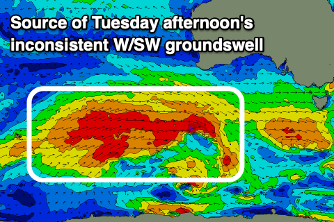
Now, looking at the stronger Southern Ocean frontal progression firing up between the Heard Island region and Western Australia today, we're seeing a great fetch of W/SW gales produced in our far western swell window with the swell from this source due to build through Tuesday, reaching an inconsistent 2-3ft into the afternoon.

A stronger but very west pulse of W'ly groundswell is due to follow Tuesday afternoon's swell, filling in Wednesday. This will be generated by a trailing low behind the Southern Ocean frontal progression producing a fetch of severe-gale W/NW winds south of Western Australia Monday.
The swell is due to arrive late Wednesday and reach 3ft across Clifton, then ease from 2-3ft on Thursday.
N/NW tending W/NW winds should create clean conditions all day Wednesday, gusty N all day Thursday. We'll confirm this on Monday though and in the meantime, have a great weekend!

