Plenty of swell to come with favourable winds
Southern Tasmanian Surf Forecast by Craig Brokensha (issued Wednesday August 16th)
Best Days: Most days this period
Features of the Forecast (tl;dr)
- Inconsistent W/SW groundswell possibly showing late today, peaking tomorrow with N tending E/NE winds tomorrow, NW tending W/NW Fri ahead of a SW change in the PM
- Small-moderate sized W/SW groundswell Sat with fresh N/NW tending W/NW winds, easing Sun with N/NW-NW winds
- Reinforcing small W/SW swell Sun/Mon
- Moderate sized W/SW groundswell Wed with NW tending W/NW winds ahead of a possible late SW change
Recap
Clean, fun easing surf from the 2ft range yesterday morning, smaller today and back to 1-1.5ft.
This week and weekend (Aug 17 - 20)
Our inconsistent W/SW groundswell for tomorrow is still on track, with it generated by a strong but distant polar frontal progression that moved through the Southern Ocean between South Africa and Western Australia.

Slow 2ft sets are due tomorrow, easing Friday with N tending E/NE winds tomorrow and NW tending W/NW winds Friday ahead of a strong afternoon SW change.
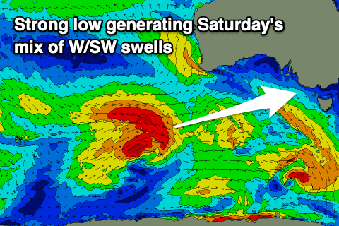
This change will be linked to the remnants of a strong low that's currently moving in from the west clipping us, bringing with it a moderate sized increase in W/SW swell Saturday.
The low developed east of the Heard Island region yesterday and is generating a fetch of W/NW come W/SW gales.
2-3ft sets are due across Clifton and with N/NW tending W/NW winds again as another front clips us.

This frontal system looks to generate a reinforcing pulse of mid-period W/SW swell Sunday and Monday that should keep Clifton topped up around 2ft.
Longer term, a much more significant Southern Ocean frontal progression looks to fire up south-west of Western Australia, moving slowly east through our western swell window and possibly restrengthening directly south-west of us on Tuesday.
Regardless of the latter stages, we've got a moderate sized W/SW groundswell on the cards for next Wednesday under favourable NW-W/NW winds. We'll have a closer look at this on Friday though to nail down the sizes and winds.

