Building surf into the weekend as winds go onshore
Southern Tasmanian Surf Forecast by Craig Brokensha (issued Wednesday August 9th)
Best Days: Late Friday, Saturday morning, Monday
Features of the Forecast (tl;dr)
- Tiny surf tomorrow and Fri AM with NW tending W/SW winds tomorrow, N/NW Fri
- Late increase in new W/SW swell Fri
- Moderate sized mid-period W/SW swell building Sat with W/NW tending gusty W/SW winds
- Peak in swell Sun with strong SW tending S/SW winds
- Moderate sized S'ly swell Mon, easing with NW tending SE winds
Recap
Fading surf through yesterday though still 1-1.5ft with nice conditions, holding 1-2ft today which is a bit bigger than expected.
This week and next (Aug 10 - 18)
Tomorrow and Friday should be tiny but seeing today's size we may see 1-1.5ft sets persisting tomorrow, and to 1ft on Friday.
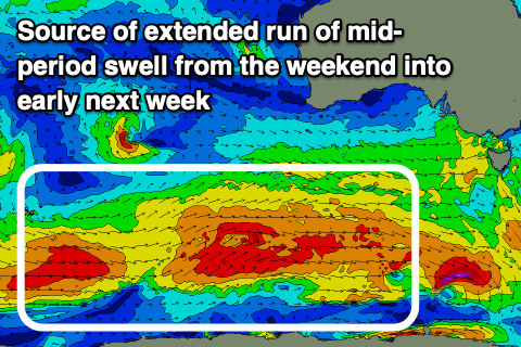
Later in the day Friday some new mid-period W/SW swell may be seen though the weekend is a more reliable chance for this, with a healthy, strengthening polar frontal progression due to move in from the south-southwest of Western Australia over the coming days.
This will see initial patchy fetches of strong W/SW winds reach the gale-force range, producing building levels of moderate sized, mid-period W/SW swell Saturday, peaking Sunday and then easing slowly through next week.

The swell pulse late Friday may reach 1-2ft and with persistent N/NW winds. Saturday looks better with building sets to 3ft through the afternoon, easing from a similar size Sunday morning.
Unfortunately winds will deteriorate as a front attached to the swell generating progression moves through Saturday, and then forms a low south-east of us Sunday.
This will see W/NW tending fresh W/SW winds on Saturday and then strong SW tending S/SW winds through Sunday when the swell peaks.
Some mid-period S'ly swell is likely to spread up from the low on Monday, maintaining 3ft+ surf as winds improve, tending light NW ahead of weak SE sea breezes.
Easing surf is due through the middle of the week, with some small W/SW energry on the cards for late week, but we'll have a closer look at this on Friday.

