Rare run of persistent S'ly swell
Southern Tasmanian Surf Forecast by Craig Brokensha (issued Monday January 31st)
Best Days: Tuesday morning, protected spots Wednesday through Friday, Sunday morning selected spots
Features of the Forecast (tl;dr)
- Small SW swell tomorrow with fresh N tending weaker W/NW winds ahead of a strong W/SW change around midday
- Moderate sized S'ly swell from Wed through Fri with onshore winds from the SW-S/SW
- Easing S swell Sat with a building S/SW swell for the PM, peaking Sun
- Strengthening E/NE winds Sun
Recap
Onshore tiny surf to kick off the weekend, better yesterday with a new swell and clean conditions across selected breaks, easing back to 1-1.5ft today but nice and clean.
This week and weekend (Feb 1 - 6)
With the weekend's inconsistent W/SW groundswell easing into today, we've got a small reinforcing pulse of SW swell due tomorrow, generated by a late forming low in our swell window yesterday.
 Small 1-2ft waves are due across Clifton and conditions will be cleanest early with a fresh N'ly, easing and tending W/NW before a strong W/SW change moves through around midday.
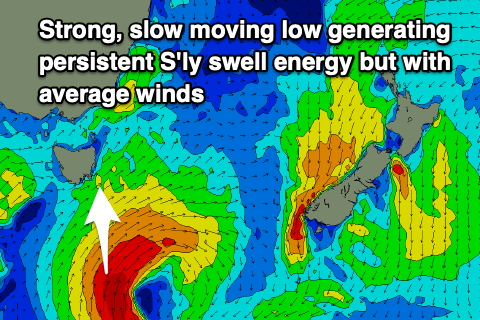
This change will be linked to a strengthening trough pushing in from the west, forming a tight low under us tomorrow evening.
This will direct a great fetch of strong to gale-force S'ly winds through our southern swell window, producing a solid spike of mid-period S'ly swell Wednesday morning to 3ft to maybe 4ft but with strong SW winds, easing through the day.
The low is forecast to remain at strength while slowly shifting south-southeast through Wednesday and Thursday which is quite rare for such a system. This will continue to generate moderate levels of S'ly swell for Thursday and Friday in the 3ft+ range across Clifton but with W/SW tending SW winds on the former, lingering from the SW on the latter.
The S'ly swell energy will fade into the weekend with some smaller, mid-period S/SW swell from weak polar fronts due to move in Saturday and Sunday.
This should keep 2ft sets hitting Clifton as winds slowly improve. Saturday looks to still be onshore from the S/SE with strengthen E/NE tending NE winds on Sunday.
Longer term the outlook is slower so try and work the coming S'ly swells.

