Quiet run continues
Southern Tasmanian Surf Forecast by Craig Brokensha (issued Monday January 24th)
Best Days: Sunday selected spots, Monday morning
Features of the Forecast (tl;dr)
- Tiny SW swell Wed with E tending stronger E/NE winds
- Inconsistent W/SW groundswell Sun with increasing NE winds
- Easing W/SW groundswell with N tending E/NE winds
Recap
A small pulse of SW swell came in bigger than expected on Saturday with sets to 2ft across Clifton with clean conditions, back to 1ft yesterday and micro today.
This week and weekend (Jan 25 - 30)
In short the outlook remains poor with tiny surf this week and a decent swell Sunday but with dicey winds as a trough moves across us.
 Tomorrow will be tiny but a small lift in tiny swell is due Wednesday, generated by a weak polar front that's currently passing under us. Size wise it'll be ideal for beginners and to 1ft+ or so but winds are the main issue. A moderate E'ly breeze is expected, creating average conditions across Clifton, with strengthening E/NE breezes due into the afternoon.
Moving into the weekend, the surf will remain tiny Saturday and a low and trough moving across us will bring fresh S/SW winds, shifting NE on Sunday as a high follows, along with a new W/SW groundswell.
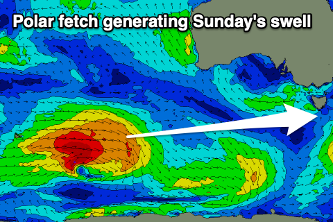
This swell will be generated by a strong polar frontal system firing up around the Heard Island region tomorrow afternoon. A great though distant fetch of gale to severe-gale W/SW winds will be projected through our swell window, with the storm weakening south of Western Australia Thursday evening.
It'll be inconsistent and west in nature but sets to 2ft are due with that NE breeze. Monday should be fun with the swell easing from 1-2ft with N tending strong E/NE winds.
Longer term another weaker polar low may generate a W/SW swell for mid-week but more on this Wednesday.

