Dicey winds with small swells ahead of more activity next week
Southern Tasmanian Surf Forecast by Craig Brokensha (issued Wednesday November 10th)
Best Days: Sunday, Tuesday morning and Wednesday
Features of the Forecast (tl;dr)
- Small mid-period SW swells from Fri through Sun AM with onshore winds Fri/Sat, cleaner Sun with a N/NW tending W/NW breeze
- Mix of mid-period SW swell and S/SW windswell Mon with strong W/SW tending SW winds
- Easing mix of swells Tue with fresh W/SW-SW winds (likely W/NW early)
- Easing surf with NW winds Wed
Recap
The best pulse of W/SW swell provided fun surf yesterday morning with clean conditions and variable winds, while today conditions were clean again but the surf tiny and fading. A trough has since moved through bringing onshore S'ly winds.
This week and next (Nov 11 – 19)
We've got a couple of small swells due into the end of the week and weekend, generated by weak polar frontal activity moving through our swell window today and over the coming days.
Size wise it's nothing special and winds will remain a problem with 1-2ft surf under W/SW-SW tending S/SE winds Friday, remaining bumpy Saturday with S-S/SE winds and similar sized surf.
 Sunday morning looks the cleanest with N/NW tending W/NW offshores and easing surf from 1-2ft.
This will be ahead of a strengthening polar frontal progression pushing up and towards Victoria.
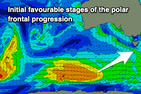
The initial stages of the frontal progression on the polar shelf will be favourable for swell production, but as it projects north towards South Australia during Saturday, it'll be far less favourably aimed, with the tail of it moving through Monday, bringing strong S/SW winds.
Swell wise, a mix of mid-period SW swell from the initial stages and localised windswell are due Monday with surf to 3-4ft expected but with strong W/SW tending SW winds.
 Similar but weaker winds are due Tuesday as the swell eases from the 3ft+ range but we'll hopefully see early W/NW winds across Clifton.
Wednesday will be clean but smaller and easing from 2ft.
Following this initial frontal progression a secondary stronger polar frontal progression may fire up south-west of us through mid-late next week generating a larger, stronger swell for Friday-Sunday.
We'll have a closer look at this in the coming updates though.

