Tricky week with mostly onshore winds and tiny surf
Southern Tasmanian Surf Forecast by Craig Brokensha (issued Monday November 8th)
Best Days: Tomorrow morning, Tuesday morning next week
Features of the Forecast (tl;dr)
- Small, mid-period W/SW swell tomorrow with variable tending fresh S/SE winds
- Easing swell Wed with light W/SW tending fresh S'ly winds
- Small SW swell Fri with S/SE winds
- Small SW swells Sat/Sun withonshore winds
- Better SW swell for Mon with strong SW winds, easing Tue with W tending SW winds
Recap
Not much in the way of surf with swells incoming from the west being too small, west in nature and low period to really trouble the South Arm.
This week and weekend (Nov 9 – 14)
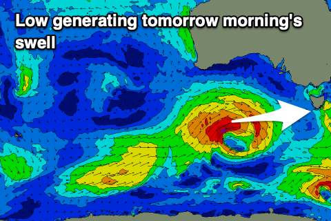
 While the last couple of days haven't provided much in the way of surf, our best pulse of mid-period W/SW swell for tomorrow is still looking decent for a wave. The swell generating low linked to it moved in from under Western Australia during the weekend, generating a good fetch of W/SW gales.
The swell should peak tomorrow morning to a good 2ft across Clifton, if not for the odd bigger one at eastern ends. Conditions look workable with a variable breeze after a pre-dawn SW'ly, giving into fresh S/SE breezes from mid-afternoon.
The swell will ease through Wednesday from 1-1.5ft but with a light W/SW tending fresher S'ly wind.
From the end of the week, we'll see polar frontal system start to fire up through our south-western swell window, becoming stronger into the weekend.
The first in this progression looks to generate a small, 1-2ft spike in swell for Friday, generated by pre-frontal W/NW winds. Unfortunately S/SE winds will create bumpy conditions and average surf.
 A secondary fetch of weak W'ly winds should produce 1-2ft of swell through Saturday and Sunday but winds continue to be a problem and mostly onshore due to troughy weather passing through.
Of greater significance is a broader, stronger polar frontal progression firing up on the weekend, generating some better mid-period SW swell for early next week. Initially winds look strong from the SW as the fronts moves through Monday, hopefully cleaner with a morning W'ly wind on Tuesday as the swell eases.
Size wise it looks to be in the 3ft range, but more on this in the coming updates.

