Get stuck in tomorrow before things go quiet
Southern Tasmanian Surf Forecast by Craig Brokensha (issued Monday November 1st)
Best Days: Tuesday morning, Wednesday for the desperate, exposed spots Saturday
Features of the Forecast (tl;dr)
- Easing W/SW-SW swell tomorrow with N/NE tending strong E/NE winds
- Smaller, fading surf Wed with gusty NE tending lighter N/NW winds ahead of a late SE change
- Tiny W'ly swell building Fri with E winds, easing Sat with E/NE-NE winds
Recap
A severe low crossed over the state on Friday and kicked up a stormy increase in swell which eased and tried to clean up Saturday, dropping from a lumpy, raw 3ft. Yesterday was much cleaner and fun with sets easing from 2ft.
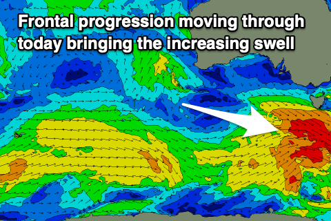
Today the surf was a touch smaller and back to 1-2ft, but a strong frontal system pushing under us has since brought an onshore change and building W/SW swell.
This week and weekend (Nov 2– 7)
 Make the most of the swell over the coming days, as the outlook for the longer term is very lean on regarding decent surf getting into the South Arm.
Today's building swell was generated by a strong frontal progression developing under Western Australian on the weekend, projecting east while generating various fetches of strong to gale-force W/NW winds in our western swell window.
The progression has since moved through and we'll see it clearing to the east tomorrow as the W/SW groundswell seen this afternoon peaks overnight and eases tomorrow. Good 2-3ft sets are due across Clifton, easing through the day under a light N/NE tending strong E/NE breeze.
Wednesday will be much smaller and 1ft to possibly 2ft, fading through the day with gusty NE winds ahead of a weaker N/NW wind shift as a trough approaches from the west, swinging SE late afternoon/evening as the trough moves through.
 Following this, we'll see weak mid-latitude fronts pushing up towards Western Australia, dipping south-east on approach to us and too far north through our swell window to generate any decent swell.
A tiny 1ft wave may be seen off this activity Friday afternoon and Saturday morning but with E/NE-NE winds. Try more exposed breaks.
Following this there's nothing too significant on the cards, though we might see a fun swell mid-next week. Check back on Wednesday for more regarding this.

