Poor tomorrow but improving thereafter
Southern Tasmanian Surf Forecast by Craig Brokensha (issued Friday October 15th)
Best Days: Sunday, Monday morning, Wednesday
Features of the Forecast (tl;dr)
- Inconsistent W/SW groundswell tomorrow with a building S/SE swell. Strong S/SW tending SW winds
- Easing mix of swells Sun with a W/NW tending variable breeze ahead of sea breezes
- Good SW groundswell Mon with N/NW winds ahead of a strong S/SW change early PM
- Easing swell Tue with S winds
- Small S/SW swell Wed with N/NE winds
Recap
Wednesday's fun pulse of swell faded back yesterday and is tiny today with average winds.
This weekend and next week (Oct 16 – 22)
After a week of very slow and generally average swell we've got a dynamic weekend of waves ahead, but it'll be mostly onshore.
Firstly an inconsistent W/SW groundswell is due to fill in and peak tomorrow, generated earlier in the week by a distant but strong polar low east of the Heard Island region.
This should provide inconsistent 2-3ft sets, but a deepening mid-latitude low across us through the weekend will bring strong S/SW tending SW winds tomorrow and a building S'ly swell that looks to be bigger than the groundswell.
With wind strengths not quite reaching gale-force the swell will be quite weak, with strong S-S/SE winds projected up into us through the day. Building surf to 3ft+ or so through the day, easing back from 2ft to maybe 3ft on Sunday morning. Winds now look better for Sunday with a W/NW offshore due across Clifton, tending variable ahead of sea breezes. Get in through the morning for the most size.
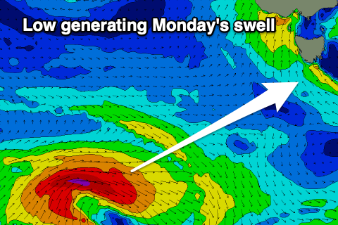
 We then look at Monday's fun SW groundswell with a small strong low firing up under the country this afternoon. A fetch of gale-force W/SW winds are forecast to be projected east through our swell window, with fun 2-3ft sets expected across Clifton on Monday when it peaks.
Winds will be great and offshore from the N/NW ahead of a trough and S/SW change into the afternoon.
The trough will linger into Tuesday with S'ly winds persisting across the South Arm as the swell eases.
We might see a weaker, mid-period S/SW swell from a trailing front of weak SW winds through our southern swell window early next week, arriving Wednesday, providing 2ft sets and with more favourable N/NE winds but we'll confirm this Monday.
Otherwise there'll be lots of storm and swell activity for Western Australia and the East Coast next week and beyond, but too north for us. Therefore make the most of Sunday and Monday mornings. Have a great weekend!


Comments
Has anyone hiked around the south west national park of tas in summer like around Jan. like everywhere over summer there’s marsh flies, but are there some areas that are pretty unbearable, think I can recount someone telling me they were shocking.