Building swells into the weekend, cleanest early next week
Southern Tasmanian Surf Forecast by Craig Brokensha (issued Wednesday October 13th)
Best Days: Monday ahead of the change
Features of the Forecast (tl;dr)
- Inconsistent W/SW groundswell Sat with a building S/SE swell. Strong S/SW winds
- Peak in S/SE swell Sun AM easing with fresh SW winds
- Fun SW swell building Mon with N/NW winds ahead of a late afternoon S/SW change, easing Tue with S winds
Recap
The surf was a little bigger than expected yesterday with clean 1-2ft sets reported in the Arm, tiny today.
This week and weekend (Oct 14 – 17)
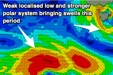
We'll see the surf remain tiny into the end of the week and with less favourable conditions as a slow moving mid-latitude low that's currently in the Bight slowly drifts south-east and across us, bringing gusty NE winds tomorrow, and E/SE tending stronger SE winds on Friday.
This strengthening SE breeze will be as the low restrengthens east of us and we'll see a slim fetch of relatively weak S/SE-S/SW winds aimed through our swell window Saturday and then into us through the evening.
 This will bring building levels of S/SE swell on Saturday to 2ft+ later in the day, peaking Sunday to the 2-3ft range before easing. Unfortunately winds will remain poor and strong from the S/SW on Saturday, and SW on Sunday as the low continues to influence local winds.
Also in the mix on Saturday should be an inconsistent W/SW groundswell, generated by a strong polar low firing up in the Heard Island region on the weekend, with it weakening south-west of Western Australia this morning.
There'll be a wait for the sets but 2ft waves are due from this source Saturday ahead of the building S/SE swell.
Monday onwards (Oct 18 onwards)
As the S'ly swell fades through Monday we should see a fun new SW swell filling in, generated by a tight but healthy polar low firing up under the country on the weekend.
A fetch of strong to gale-force W/SW winds should generate a fun pulse of swell to 2-3ft through the day under a N/NW offshore, giving into a late S/SW change as a trough moves through. The trough will leave lingering onshore winds on Tuesday as the swell eases.
Following this there's nothing significant on the cards for the rest of the week so try and work the window of cleaner conditions Monday.

