Nothing to surf until the weekend, but with onshore winds
Southern Tasmanian Surf Forecast by Craig Brokensha (issued Monday October 11th)
Best Days: Selected spots Saturday and Sunday, Monday morning and Tuesday next week
Features of the Forecast (tl;dr)
- Moderate sized S/SE swell Sat with strong S/SE tending S/SW winds
- Easing S/SE swell Sun with W winds
- Fun SW groundswell building Mon, peaking Tue AM with N winds
Recap
Ideal conditions for beginners on Saturday with clean 1ft surf, a little bigger yesterday and to 1-1.5ft but wind affected. Today remains onshore and sloppy with no real size.
This week and weekend (Oct 12 – 17)
 As touched on last week, the outlook for the coming week isn't favourable at all. We're seeing unstable, troughy activity and frontal systems sitting too far north of our swell window to wrap into the South Arm.
The East Coast is still looking very active into the end of the week and weekend so keep an eye on their Forecaster Notes in the coming hours.
But coming back to this week, the surf will be tiny to flat and with persistent, strengthening winds from the north-eastern quadrant as a high moves in from the west, squeezed by a slow moving mid-latitude low in the Bight.
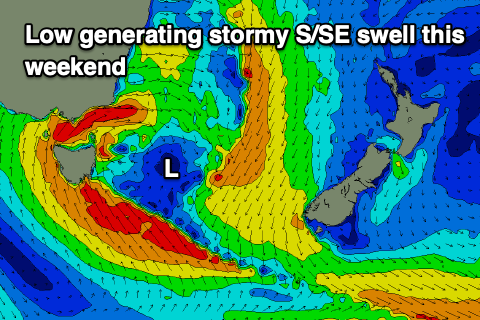
Once this low finally moves in on the weekend, the models have it re-strengthening immediately off our east and this looks to bring strong S/SE-S/SW winds on Saturday along with a stormy S/SE swell.
 At this stage we're looking at surf to 4-5ft or so but with strong winds out of the south, shifting more W as the swell eases on Sunday. There should still be plenty of size Sunday morning, while Monday will be nice and clean under a N'ly flow but smaller, fading surf.
Longer term there's a good SW groundswell on the cards for early next week generated by a polar low firing up under the country. This is due to arrive Monday afternoon and peak Tuesday morning with those favourable offshore winds from the N'th, but more on this Wednesday.

