Fading S/SE swell and then slow
Southern Tasmanian Surf Forecast by Craig Brokensha (issued Monday October 4th)
Best Days: Tomorrow morning, Friday morning but mostly for beginners
Features of the Forecast (tl;dr)
- Small, easing S/SE swell tomorrow with light N/NE tending S/SE winds
- Inconsistent, small W'ly swell Fri with N/NW tending variable and then late S/SE winds
- Possible swell Sun/Mon but with developing onshore winds
Recap
Average surf on Saturday with a bit of swell but onshore winds, stormy yesterday morning but building from the SE into the afternoon along with strong onshore winds.
Today the SE swell was stronger and to 2-3ft (bigger down the Arm) but with lumpy/bumpy conditions under a local variable breeze.
This week and weekend (Oct 5 - 10)
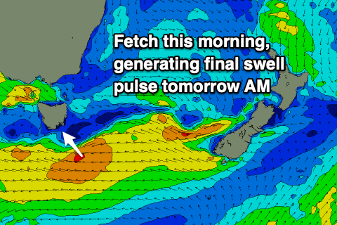
 The stalling low linked to our current S/SE-SE swell is still sitting south of us, generating a great fetch of strong to gale-force E'ly winds. The low will start to aim away from us this afternoon, with some small S/SE swell due to continue tomorrow morning before fading into the afternoon.
Clifton should see 2ft sets, bigger down the South Arm, fading through the day and tiny Wednesday.
The only issue tomorrow are the local winds and we're now expected to see light N/NE tending variable breezes, ahead of weak S/SE sea breezes.
This will favour some spots over others, but not those seeing the most size.
A cold front will move through Wednesday bringing strong W/NW tending lighter W/SW winds but no new swell with it.
 Unfortunately the rest of the period is flukey at best, with a tight and slow moving low due to form south of Western Australia, west of us tomorrow. A slim fetch of W/SW gales will just fall in our swell window, possibly generating 1ft to occasionally 2ft of swell for Friday.
Conditions look great with an offshore N/NW tending variable breeze ahead of late sea breezes, with the swell easing through the day and being tiny Saturday.
Longer term, there's a possible weak swell source for later in the weekend and early next week, that being a broad but not overly strong low forming south-west of us, but the only issue are the fetch strengths and local winds. It looks like no major size is due and winds will go onshore when it peaks, more on this Wednesday though.

