Good swells but tricky and mostly onshore winds
Southern Tasmanian Surf Forecast by Craig Brokensha (issued Wednesday September 29th)
Best Days: Selected spots tomorrow
Features of the Forecast (tl;dr)
- Easing mid-period SW swell tomorrow with light-mod E/NE winds (possibly NE at times)
- Reinforcing SW swell Fri with strengthening E/SE tending SE winds
- Easing SW swell Sat with moderate S/SE winds, stronger S/SW Sun and smaller
- Small SE swell late Sun and Mon with S winds
Recap
A fun amount of swell yesterday but a bit straight on certain tides, cleanest ahead of sea breezes. Today the start of the onshore winds was evident with 1-2ft surf but some small bumps and chops.
Into this afternoon a good new SW swell is due with sets to 3ft due but with freshening SE winds.
This week and weekend (Sep 30 – Oct 3)
This afternoon's SW swell is due to peak overnight but there'll still be plenty of size on offer for tomorrow morning with easing sets from a similar 3ft.
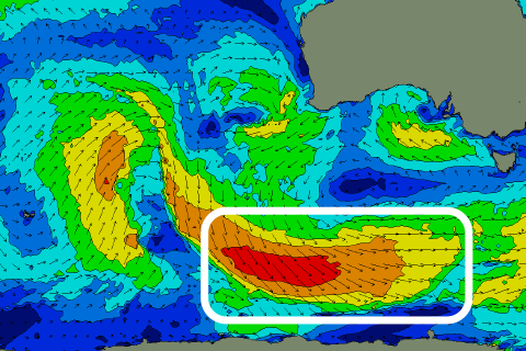
 This and a secondary pulse of reinforcing swell for Friday (3ft again) have and are still being generated by a series of not overly strong but favourably tracking polar frontal system through our swell window, under the country since early in the week (right).
The broad low that's moving in from the south-east now looks to stay a little more favourable in position for us regarding local winds tomorrow.
We're looking at a light to moderate E/NE breeze, which isn't favourable for Clifton but better for other locations, possibly shifting more NE at times through the day.
Friday isn't quite as favourable with winds due to swing E/SE and strengthen (SE into the afternoon), creating poor conditions.
The mid-period SW swell pulses are due to slowly ease through the weekend but the low will stay stalled to our south-east, bringing moderate S/SE winds on Saturday, stronger S/SW Sunday as we fall under the western flank of the low.
The position of this low and its swell producing fetch aren't favourable for swell production out of the SE until Sunday. With this we may see some small 2ft waves spreading up later in the day Sunday but more so Monday. Winds may improve Monday but the models diverge regarding this so check back on Friday for the latest on this.
Longer term there's nothing on the cards for next week with mid-latitude storms pushing up and into Western Australia. There might be some weak westerly swell late week from the activity drifting south-east across us, but more on this Friday.

