Plenty to work with over the coming days
Southern Tasmanian Surf Forecast by Craig Brokensha (issued Wednesday September 22nd)
Best Days: Tomorrow, Friday, Sunday morning, Monday, Tuesday, Wednesday morning
Features of the Forecast (tl;dr)
- Strong SW groundswell building tomorrow, peaking into the PM, easing Fri
- Fresh NW winds, tending W/NW and strengthening through the morning then W/SW into the PM
- Strong N/NW tending NW and then W/NW winds Fri
- Moderate sized mix of W/SW and S/SW swells Sat with strong W/SW tending SW winds
- Easing mix of swells Sun with W/NW tending SW winds
- Small, mid-period swells Tue-Fri next week
Recap
A bit of swell yesterday but sloppy with W/SW winds, best in protected spots for the keen. Today cleaner conditions are prevailing with a small, 2ft of swell.
This week and weekend (Sep 23 - 26)
Currently, a significant polar frontal progression is projecting a fetch of W/NW gales under us, this being the final system in a significant progression the last couple of days to the south of Western Australia and under the country.
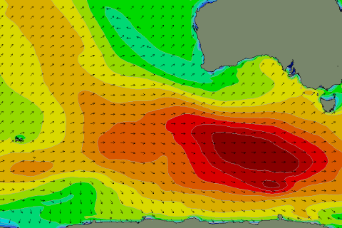
 We should see a moderate sized long-period SW groundswell spreading out and into us tomorrow (shown today south of the country in the image right), building through the day and reaching a solid 4ft+ across Clifton into the afternoon.
A trailing fetch of W/SW gales moving through our swell window tomorrow will slow the easing trend, with Friday dropping from 3-4ft.
Our reinforcing swell for the afternoon and Saturday looks to be more aimed into Victoria, as that's where the developing polar low will be focussed will be initially focussed through Friday.
In saying this we'll still see a strong fetch of SW-S/SW winds projected up towards us through Friday evening and Saturday morning as the backside of the low moves through, producing a mix of moderate sized S/SW swell Saturday, mixed in with reinforcing W/SW groundswell.
Surf to 3-4ft is due, easing back from the 2-3ft range on Sunday.
Coming back to the local winds and a fresh NW breeze will strengthen from the W/NW tomorrow morning, shifting W/SW into the afternoon when the most size is due.
Friday morning should see strong N/NW winds, shifting NW and then W/NW into the afternoon, while Saturday still looks poor with strong W/SW tending SW winds.
Sunday should be cleaner with a morning W/NW breeze though shifting SW through the day.
Longer term, weaker polar frontal activity should produce some small, mid-period swell from Tuesday onwards, but more on this Friday.

