Lots of windy swell on the way
Southern Tasmanian Surf Forecast by Craig Brokensha (issued Monday September 20th)
Best Days: Wednesday, Thursday, Friday, Sunday
Features of the Forecast (tl;dr)
- Bumpy, inconsistent W/SW groundswell tomorrow mixed with weaker S/SW swell under fresh W'ly winds
- Building, mid-period SW swell Wed with N/NW winds
- Larger SW groundswell building Thu, peaking into the PM, easing Fri
- Strong dawn N/NW winds, tending W/NW mid-late morning and W-W/SW into the PM
- Strong N/NW tending W winds Fri with a new swell building into the PM
- Easing W/SW groundswell Sat with strong W/SW tending SW winds, cleaner and easing further Sun
Recap
Tiny, clean waves to kick off the weekend, with a touch more size as a new mid-period W/SW swell filled in yesterday, similar today.
This week and weekend (Sep 21 - 26)
With the small to tiny pulses of swell out of the way, we look at our better and more reliable swells due through this week.
Firstly a new W/SW groundswell is due tomorrow, generated by a strong low firing up south-southwest of Western Australia on the weekend, projecting a fetch of weakening severe-gale W/SW winds towards us. This should generate an inconsistent 2-3ft of swell for tomorrow morning, but there’ll also be some weaker, mid-period S/SW swell from the backside of the front as it pushes up and into us today.
 Unfortunately this front will bring strong onshore winds overnight that will only start to improve around dawn, swinging W’ly but still fresh and remaining that way all day. This will favour protected spots which will be smaller, while Clifton should see that mix of swells to 2-3ft but with bumpy/choppy conditions.
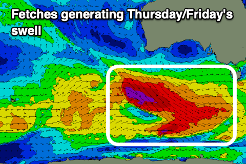
Of greater importance is the polar frontal progression firing up behind today’s front, with back to back, significant fetches of gale to severe-gale W/NW winds pushing through our swell window from today through Wednesday, with each front getting stronger.
This will see building levels of size and energy, with the first pulse of mid-period swell due to build Wednesday, head of the strongest pulse of groundswell Thursday, peaking into the afternoon and then easing slowly Friday (but as a new swell fills in).
 The swell will build to 2-3ft during Wednesday along with N/NW winds, with Thursday’s swell likely to reach 4-5ft into the afternoon. This will be with strong N/NW tending W/NW, then W-W/SW winds as one of the polar fronts clips the state, favouring protected spots.
Friday looks cleaner across Clifton in the morning with strong N/NW winds ahead of another W/SW change as a strengthening polar front pushes up and into us. This will likely see the morning building from 3-4ft back to the more consistent 4ft range, with Saturday morning coming in at 3-5ft, easing through the day but with strong W tending SW winds.
Longer term the outlook remains active for us, but not to the size of this week. More on this Wednesday.

