Good swell ruined by onshore winds tomorrow, cleaner as it eases
Southern Tasmania Surf Forecast by Craig Brokensha (issued Wednesday 25th August)
Best Days: Thursday, Friday morning beginners, next Tuesday beginners
Features of the Forecast (tl;dr)
- Good SW groundswell tomorrow morning but with strong S winds
- Easing SW groundswell Fri with variable E winds, tending variable into the PM
- Fading SW swell Sat with N tending E/NE winds
- Tiny W'ly groundswell for Tue
Recap
Our inconsistent new W/SW groundswell filled in as forecast yesterday with clean, fun 2-3ft waves across Clifton. Today the swell has dropped back and with an onshore wind owing to a strong low forming off the southern NSW coast.
This week and weekend (Aug 26 - 29)
Looking at tomorrow and unfortunately the strong low off the southern NSW coast will be slow moving and drift further south through the day, keeping strong S'ly winds impacting the South Arm.
This will spoil a new, moderate sized SW groundswell that should be showing late today, peaking at 3-4ft tomorrow morning. The source of this was a great polar frontal progression pushing through our swell window the last couple of days and we'll see the swell backing off from 2ft+ on Friday morning as winds go more variable. They'll have some east bias, favouring some breaks over others ahead of weak sea breezes, if anything.
 Saturday looks clean but only small with fading 1-2ft sets under a N tending E/NE breeze.
Longer term, as touched on in Monday's update, the storm track will be too far north and west of our main swell windows to generate any significant surf.
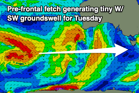
A pre-frontal fetch of strong to gale-force W/NW winds moving through our swell window may generate 1-1.5ft of swell for Tuesday, while a stronger polar front projecting towards Western Australia may generate 1-2ft of W'ly swell for next Thursday. Otherwise make the most of the coming days of swell.

