Good swell but with onshore winds
Southern Tasmania Surf Forecast by Craig Brokensha (issued Friday 20th August)
Best Days: Tomorrow morning, Friday morning, Saturday for beginners
Features of the Forecast (tl;dr)
- Inconsistent W/SW groundswell tomorrow with NW tending W/SW winds
- Better SW groundswell building later Wed, peaking Thu AM but with strong S/SW winds Wed and moderate S/SW Thu
- Easing swell Fri with variable E winds, smaller Sat with N winds
Recap
Tiny waves for beginners on Saturday, near flat on Sunday. Today some weak, mid-period energy has provided 1-1.5ft surf with bumpy conditions.
This week and weekend (Aug 24 - 29)
With a slight increase in size today, we should see some better, inconsistent W/SW groundswell filling in tomorrow, generated by a strong polar low that generated a fetch just within our swell window late last week and on the weekend.
Inconsistent 2-3ft sets are due across Clifton tomorrow with a N/NW offshore, swinging W/SW into the afternoon but without much strength.
 The swell will ease into Wednesday morning and winds will go onshore from the S/SW as a strong low forming off the southern NSW coast shifts further south towards us.
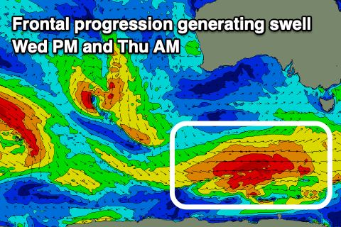
This will also spoil a new SW groundswell that's due to build into the afternoon and peak through Thursday morning.
The source of this swell will be a strong polar frontal progression firing up under the country this week, projecting W-W/SW gales through our swell window.
The swell should peak to 3-4ft across Clifton but winds will persist from the S/SW, not as strong as Wednesday but still onshore.
Friday looks cleaner with more variable winds from the E but the swell will be on the way out, easing from 2ft+, and then 1-2ft on Saturday.
Longer term the outlook remains slow until a vigorous polar frontal progression fires up towards WA on the weekend. We may see some fun W/SW groundswell spreading off this for us mid-next week, but we'll keep an eye on this.

