Slim weekend pickings, better next week
Southern Tasmania Surf Forecast by Craig Brokensha (issued Friday 20th August)
Best Days: Beginners tomorrow, Monday morning, Tuesday for the keen, Thursday
Features of the Forecast (tl;dr)
- Fading S/SE swell tomorrow with N tending NW winds
- Mid-period W/SW swell for Mon with W/NW tending SW winds
- Better mix of W/SW and SW groundswell Tue with W/SW-SW winds
- Easing swell Wed with strong S winds
- Good SW groundswell Thu with variable winds
Recap
A further drop in size yesterday but a small mix of swells kept 1-2ft waves hitting Clifton with favourable conditions.
Today the surf is back to 1-1.5ft but a new S/SE swell that was expected to show through the day should maintain this size with the odd 2ft'er in the mix
This weekend and next week (Aug 21 - 27)
 Any small pulse of S/SE swell seen this afternoon is due to ease back through tomorrow from 1-1.5ft across Clifton. Conditions will be great for beginners though with a N tending NW breeze.
Following this, we've got some tricky W/SW swells on the cards from a strong but not overly favourably aligned polar storm firing up towards Western Australia and then South Australia over the coming days.
We're now expected to see a small fetch of gale to severe-gale W/SW winds projected through our western swell window today and tomorrow.
This should produce an inconsistent W/SW groundswell for Tuesday, but ahead of this on Monday some smaller, mid-period energy is due, from the head of the storm. Slow 1-2ft sets should be seen across Clifton with Tuesday coming in at a better 2-3ft.
 Winds look OK early Monday and W/NW, shifting SW through the day with Tuesday looking dicey as a trough feeding up into a forming low off the southern NSW coast brings W/SW-SW winds. There may be a period of morning W/NW breezes but we'll look at this closer Monday.
As the low forms and drops south through Wednesday it looks like we'll see string S'ly winds impacting the coast, creating poor conditions. There's a chance these winds could linger Thursday depending on how close the low stays to us, but most likely winds will go variable into Thursday morning.
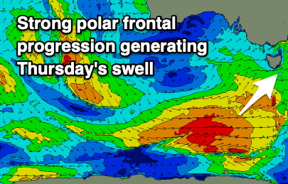
A new SW groundswell is also due on Thursday from a strong polar front firing up early next week with sets to 3-4ft likely across Clifton. Again we'll look at this in more detail on Monday. Have a great weekend!

