Strong swells, large next week
Southern Tasmania Surf Forecast by Craig Brokensha (issued Friday 13th August)
Best Days: Saturday, Sunday, Monday, Tuesday protected spots, Wednesday
Features of the Forecast (tl;dr)
- Mix of W/SW groundswell and mid-period SW swell Sat with moderate N tending N/NW winds, easing Sun with strengthening N/NW tending W/NW winds
- Large mix of swells building Mon, biggest late with strong W/NW tending W/SW winds, easing Tue with strong SW winds
- Easing S swell Wed with N/NW winds
Recap
A small, localised W/SW swell to 1-2ft yesterday morning while today we've got more size reported, likely mid-period energy ahead of a larger swell tomorrow.
This weekend and next week (Aug 14 - 20)
Today's building mid-period swell is linked to the secondary developments of a strong pre-frontal system, come polar low moving through our swell window the last couple of days.
 We've seen severe-gale W/NW winds followed by strong to gale-force W/SW winds south-west of us today, bringing the building size.
Tomorrow a mix of W/SW groundswell and SW energy is due across the South Arm with 3ft+ surf due across Clifton most of the day, easing Sunday from 2ft+. Conditions looks great with a moderate N tending NW breeze tomorrow, and then stronger N/NW tending W/NW on Sunday.
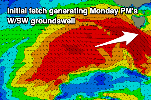
We then look at the strong polar low forming south of Western Australia tomorrow. This low will initially generate a fetch of severe-gale W'ly winds W/SW winds through our western swell window, passing across us Sunday, with weaker, strong to gale-force SW winds projected up and into us through Sunday evening, Monday and Tuesday as the low stalls.
 What will result is a moderate sized, long-period W/SW groundswell for Monday, building through the day and peaking into the afternoon to 4ft, but the close-range fetch of SW winds pushing into us look to top this and kick sets to 5-6ft by late in the day from the SW.
Accordingly winds will be strong from the W/NW Monday morning as the swell builds, shifting W/SW after lunch and then coming in strong from the SW Tuesday.
The surf will still be large Tuesday and 4-6ft out of the SW tending S/SW owing to the fetch moving more into our southern swell window as the low remains slow moving.
A much more noticeable drop in size is due Wednesday from 3ft as winds revery back to the N/NW. More on this Monday though. Have a great weekend!


Comments
How's that saying go.. When there's snow around Hobart..
And the dude is walking in shorts!!!! Bit brisk isnt it?
Ha, crazy!