Improvement to the end of the week with lots of swell to follow
Southern Tasmania Surf Forecast by Craig Brokensha (issued Wedneaday 11th August)
Best Days: Tomorrow, Friday morning, Saturday, Sunday, protected spots Monday and Tuesday
Features of the Forecast (tl;dr)
- Mid-period W/SW swell tomorrow with NW winds, easing Fri with fresh N/NW winds, shifting SW into the PM
- Mix of W/SW groundswell and mid-period SW swell Sat with N tending N/NW winds, easing Sun with strengthening NW winds
- Large mix of swells for Mon with strong W/NW tending SW winds, easing Tue with W/SW winds
Recap
Tiny, fading surf ideal for beginners yesterday, bottoming out today with a low point in swell.
This week and weekend (Aug 12 - 15)
The end of the week was looking mostly tiny on Monday, with swells arriving from the west and being generated in a poor position through our swell window.
But we've got some slight improvement for tomorrow, with the remnants of a significant frontal progression that pushed over Western Australia now moving in from the west. We're not due to see an intensification of near gale-force W/SW winds under us early tomorrow morning, kicking up 2ft of mid-period W/SW swell through tomorrow, easing back from 1-2ft on Friday.
 Winds tomorrow look great in the wake of the front and NW tending variable, with N/NW winds Friday ahead of an afternoon SW change.
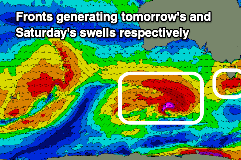
Now, we then look at the strong pre-frontal W/NW fetch come polar low and the structure of this system has changed a little.
The pre-frontal fetch is great and we'll see gale to severe-gale W/NW winds projected through our swell window over the coming days, but the post-frontal and better aligned fetch of W/SW winds is now patchy and poor in structure.
What we can expect is a good pulse of W/SW groundswell from the pre-frontal fetch on Saturday morning to 3ft, with mid-period SW energy from the tail of the front bringing similar sized sets. With this mix of swells sets just over 3ft are likely.
 Winds look great and from the N'th, tending N/NW into the afternoon, with easing surf Sunday from 2ft+ with strengthening NW winds.
With the first low not being as strong as forecast, we've got a secondary low on the cards now, forming south-west of us on the weekend and projecting severe-gale W/SW winds through our western swell window, followed by SW gales Monday.
A moderate sized W/SW groundswell is due from the W/SW fetch with an additional SW swell in the mix, peaking Monday with 4-5ft+ sets due across Clifton though with strong W tending SW winds.
Tuesday looks cleaner with easing surf from 4ft Tuesday but with possible lingering W/SW winds. We'll look closer at this Friday.

