Strong swell for the weekend
Southern Tasmania Surf Forecast by Craig Brokensha (issued Friday 6th August)
Best Days: Early tomorrow, Sunday, Monday, early Tuesday before the swell fades
Features of the Forecast (tl;dr)
- Strong SW groundswell peaking tomorrow AM with fresh W/NW winds at dawn ahead of a strong, mid-morning SW change
- Drop in size Sun but steadying with a reinforcing mid-period SW swell under N/NW tending NE winds
- Easing SW swell Mon with N/NW tending NE winds
- W swells for late next week
Recap
A tiny start to yesterday ahead of a new pulse of W/SW swell into the afternoon, holding 2ft this morning. A further increase in mid-period W/SW swell should be building across the South Arm this afternoon as winds remain favourable for protected spots.
This weekend and next week (Aug 7 - 13)
With the first of the W/SW groundswells moving in, we then look at the larger, stronger and longer period pulse of W/SW groundswell for tomorrow.
 This was generated by a great fetch of severe-gale W/NW winds sliding in from the southern Indian Ocean, then swinging more W while forming into a polar low.
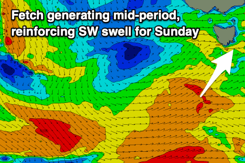
The low has since cleared to the east, but it's drawing out an elongated fetch of strong to gale-force W/SW winds behind it, generating some good reinforcing, mid-period SW swell for Sunday.
Coming back to tomorrow though and the main issue is the timing of an onshore change, and it looks to be in by about 9am, so surf early. Size wise the South Arm should see strong 4-5ft sets under a dawn W/NW breeze, shifting strong SW with the change.
We should see this front clear quickly into Sunday with winds swinging back to the N/NW, tending variable and then NE into the afternoon.
Clifton looks to be 3-4ft in the morning, likely not dropping below this until late afternoon with easing 2-3ft sets on Monday with N/NW tending NE winds again, opening up plenty of options.
 Longer term, there's a very long-period W'ly groundswell due to fill in across our West Coast late Wednesday and into Thursday, though generated by a distant and northerly positioned storm firing up towards Western Australia.
While significant in nature, the swell potential from this storm is minimal.
One the remnants of it move in from the west mid-late next week though we should see some small W'ly swell, but we'll have a closer look at this on Monday. Have a great weekend!

