Good run of swell from tomorrow afternoon
Southern Tasmania Surf Forecast by Craig Brokensha (issued Wednesday 4th August)
Best Days: Tomorrow afternoon, Friday, Saturday morning, Sunday, Monday
Features of the Forecast (tl;dr)
- Building W/SW groundswell tomorrow PM, holding Fri AM with NW tending W/SW winds both days
- Building mid-period W/SW swell Fri PM, with a stronger groundswell peaking Sat with fresh N/NW winds ahead of a strong S/SW change
- Drop in SW swell Sun but holding into the PM, easing Mon
- Moderate N/NW tending fresh N/NE winds Sun, similar and weaker Mon
Recap
Our small pulse of SW swell for yesterday afternoon started tiny in the morning, with clean conditions, while whatever swell was seen after lunch has eased back to 1-1.5ft today with onshore winds.
This week and next (Aug 5 - 13)
With the tiny, flukey swells out of the way, we've now got some good W/SW groundswells due tomorrow through the weekend, with the largest pulse due Saturday morning.
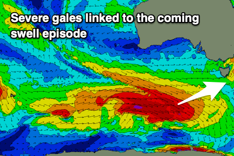
These swells are being generated by frontal system tracking east-southeast from the south-east Indian Ocean, then forming into lows along the polar shelf while tracking straighter east and closer towards us.
The first of these systems generated W/NW gales before turning into the low, swinging winds more W, with it now weakening south-west of us. This will generate tomorrow's swell with building sets from 1-1.5ft early to 2-3ft later in the day due.
 This will be with morning NW winds, tending W/SW into the afternoon but without much strength.
Of greater importance is the secondary system moving in on a similar track, with a fetch of severe-gale W/NW winds due to swing more W and push closer to us, weakening and tending W/SW while drawing out in length through tomorrow evening and Friday.
This should produce a moderate sized W/SW groundswell for Saturday, with building mid-period energy either side (Friday afternoon and Sunday).
With this Friday morning looks to hold 2-3ft, with a late increase to 3ft+ ahead of the groundswell Saturday to 4-5ft on the sets across Clifton.
The swell should drop overnight into Sunday but hold 3-4ft all day as a small intensification of the trailing frontal activity projects up towards us, generating a reinforcing SW swell.
This will then ease from 2-3ft on Monday morning.
Looking at the winds and a W/NW tending W/SW breeze is due Friday with Saturday's strongest pulse seeing N/NW winds ahead of a strong afternoon S/SW change. This change will be short-lived with winds swinging back to the N/NW on Sunday morning, fresher N/NE into the afternoon, similar Monday.
Following this there's nothing on the cards until late week, but more on this Friday.

