Mostly tiny surf with favourable winds
Southern Tasmania Surf Forecast by Craig Brokensha (issued Friday 23rd July)
Best Days: Tomorrow, Sunday through Tuesday for beginners
Features of the Forecast (tl;dr)
- Easing mid-period SW swell tomorrow with gusty N/NE winds, shifting NW late afternoon
- Tiny W/SW groundswell Sun with N tending strong W/NW winds
- Tiny W/SW swell Mon with N/NW winds
- Small S/SW swell Tue with N/NW winds
Recap
The surf hung in at a fun 2-3ft yesterday with a reinforcing pulse of W/SW swell, dropping back to 2ft today with good conditions.
This weekend and next week (July 24 - 30)
 The pulses of reinforcing swell seen through yesterday and today should hold 2ft tomorrow morning before easing into the afternoon, tiny Sunday as a distant W/SW groundswell provides infrequent 1-1.5ft sets.
Winds look favourable and gusty from the N/NE, shifting NW into the late afternoon tomorrow, N'ly early Sunday ahead of a strong W/NW change late morning.
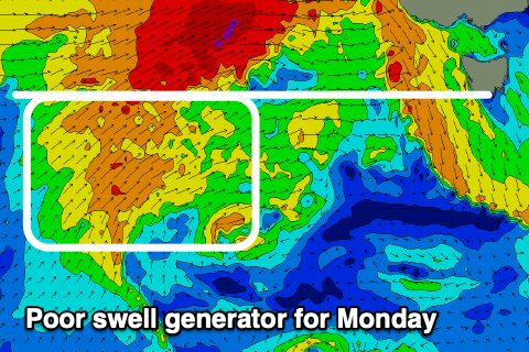
The models are showing a bit of size from the west on Monday but the source of this swell is frontal activity moving through the Bight, too far north of our swell window. Instead, a weaker fetch of W/SW winds only looks to keep 1ft+ waves hitting the South Arm with N/NW winds.
 On Tuesday a tiny S/SW swell may be seen from a strong low forming south-southwest of us on the weekend, but the bulk of the fetch will be aimed SE and towards Western Australia. As a result I wouldn't expect any real size with tiny 1.5ft waves at best.
Longer term we've got nothing significant on the cards as the stormy track stays too far north and our of our swell window. Therefore make the most of the small pulses this weekend. Have a good one!


Comments
Nice wrap Craig. Horrie