Small W/SW swells, slower next week
Southern Tasmania Surf Forecast by Craig Brokensha (issued Wednesday 21st July)
Best Days: Thursday, Friday, Saturday, Sunday (small and inconsistent)
Features of the Forecast (tl;dr)
- Fun, reinforcing W/SW swell for tomorrow afternoon, Fri and Sat AM
- N/NW tending variable winds tomorrow, fresh N tending NE winds Fri and strengthening N/NE winds Sat
- Inconsistent W/SW groundswell Sun with NW winds, fading Mon with N/NW tending N/NE winds
Recap
Small bumpy waves to start of yesterday though kicking through the day, much better today and a clean 2-3ft across Clifton.
This week and weekend (July 22 - 25)
Our current W/SW swell should ease back to 2ft tomorrow morning under great N/NW tending variable winds.
Into the afternoon a reinforcing pulse of W/SW should be seen, holding Friday, generated by W'ly winds moving in and under the country yesterday and today.
 Sets to 2ft+ are due into the afternoon tomorrow, similar Friday, easing back from 2ft on Saturday.
Conditions will be clean with N'ly tending NE winds on Friday, then strengthening N/NE through Saturday.
As talked about on Monday, the longer term outlook is fairly average with the storm track being focussed up towards Western Australia, too north of our swell window.
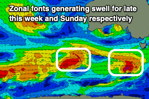
A small front ahead of this progression, moving through our western swell window tomorrow will likely produce an inconsistent W/SW groundswell Sunday to 1-2ft, but with long waits between sets.
Winds look to remain offshore from the NW Sunday, N/NW tending N/NE Monday as the swell fades.
Longer term we'll be relying on long-range W/SW groundswell energy late in the week from a strong polar low firing up south-west of Western Australia, but more on this Friday.

